HawkEye 360’s Advisory Board Adds Deliver Broad Range of Expertise

HawkEye 360 Inc. has publicized that Martin Faga, the former Director of the National Reconnaissance Office (NRO); Joan Dempsey, the former Deputy Director of Intelligence at the Defense Intelligence Agency; and former Senator Joe Donnelly have joined the company’s Advisory Board — these new additions bring extensive experience working in defense and intelligence in both the government and private sectors.


Martin C. Faga

During his time as President and CEO of The MITRE Corporation, Faga spent several years working on the integration of intelligence systems. He retired from MITRE in 2006. Prior, Faga worked extensively in the government sector. He served as Assistant Secretary of the U.S. Air Force for Space and as the Director of the NRO. From 2006 to 2009, he served on the President’s Intelligence and Advisory Board. Over the course of his career, Faga has received several honors and awards for his work from intelligence and government agencies. He said that Hawkeye 360 is pursuing a new dimension in commercial space and he is happy to have the opportunity to contribute to this fascinating and important new business.


Joan Dempsey

Dempsey joins HawkEye 360 with extensive experience in intelligence, security and business. Most recently, Dempsey held the role of Senior Partner and Executive Vice President for Booz Allen Hamilton’s defense and intelligence group. Before joining the private sector, Dempsey served more than 25 years with the federal government, which included two political appointments: Deputy Director of Central Intelligence for Community Management and Executive Director of the President’s Foreign Intelligence Advisory Board. Dempsey has also served as Deputy Director of Intelligence at the Defense Intelligence Agency. He commented that he looks forward to working with HawkEye 360 as it develops its unique data analysis and collection capabilities using RF signals. As the world grows more complex, defense and intelligence agencies must employ more sophisticated tools, such as those HawkEye 360 is building.”


Senator Joe Donnelly

Senator Donnelly served a dozen years in Congress, first representing Indiana for three terms in the U.S. House of Representatives (2007-2013) and then one term in the U.S. Senate (2013-2019). Among his committee assignments, Senator Donnelly served on the Committee on Veterans’ Affairs while in the House of Representatives and the Committee for Armed Services while in the Senate. He brings valuable public policy expertise related to defense. Senator Donnelly has a law degree from the Notre Dame Law School and currently works for Akin Gump Strauss Hauer & Feld LLP with a focus upon the financial services, defense and health care industries.


John Serafini

John Serafini, CEO, HawkEye 360, added that the addition of Marty, Joan, and Joe further deepens the breadth of experience and valuable knowledge on the HawkEye Advisory Board. The company could not ask for a more exceptional group of Advisors to lead HawkEye 360 in the firm’s mission to create a safer world through advanced RF analytics.

First Place Win for Collaboration of Dutch Companies With New Power System for SmallSats


From left to right: Mattijs Otten & Jeffrey Miog, Founding team of Tective, Bert Monna, CEO of Hyperion Technologies and Jochem Frudiger, Managing Director of GTM – Copyright: Hyperion Technologies

Three Dutch companies are celebrating their first place solution regarding a highly modular and scalable power system for small satellites.

The consortium, consisting of Hyperion Technologies, GTM Advanced Structures and Tective BV, scored first place among 31 winning subsidy applications. Starting in February 2020, the consortium will take on an 18-month journey to develop a highly modular and scalable power system for small satellites. By winning the province’s MIT Research & Development subsidy worth over €130K, the CubeSat Advanced Power System (CAPS) will soon be reality. 

Small satellites, like CubeSats and Nanosats, have come a long way to earn their respect within the scientific and commercial community. Today, many miniaturized high-performance systems and payloads exist to deliver reliable data products, for example through making use of constellations and distributed risks. Integrated power systems for these kinds of small satellites are already available. 

However, the NewSpace market is getting mature: With launch cost steadily dropping, “small” satellites can afford to grow in size, allowing for more complex payloads — not least of all because the global market is showing a growing user base for more, new or innovative space-based data products. Standardized and commercial off-the-shelf components for these sizes of satellites are, however, still a rarity. 

CAPS aims to target this growing niche of “larger” small satellites to facilitate their increased power demands. The result will consist of a high-power, end-to-end power solution for demanding payloads. A unified system architecture will allow for modular implementations of solar panels, power storage and power distribution in a variety of larger CubeSat sizes. The solution will be made tailorable for individual client needs at an affordable price.

Hyperion Technologies has been steadily expanding its product portfolio. With the development of CAPS, the company expects to be able to offer an even broader range of products for small satellites within the next two years. This will allow the company to act as a one-stop-shop, being able to supply everything needed to facilitate satellite systems for demanding CubeSat payloads.

CEO Bert Monna is clear in his vision of CAPS as he said they aim to offer clients a plug-and-play experience. The different components of CAPS will allow them to tune the system specifically to match the client’s mission profile.

GTM, with its experience in supplying advanced structures and solar panels to the space industry, will pioneer efficient solar panels for CubeSats within this project. By implementing novel ways to deploy and steer solar panels, energy output will be maximized in ways that are new to the CubeSat industry. 

Meanwhile, Tective sees opportunities to transfer new battery and charging technology into robotics. CEO and Founder Mattijs Otten added that they aim to capitalize on innovations within the CAPS project to facilitate fully autonomous robotics. In order for robots to truly start playing a significant role in remote areas, on-board power supply is critical. CAPS has all the components to start integrating solar panels and autonomous charging systems into robots aimed for exploration, surveillance and emergency response.

The CAPS team would like to extend special thanks to the province of Zuid-Holland for their enthusiasm and subsequent first place. The team is exited to start development, and will update about its progress frequently … stay tuned.

Opinion: To Secure Satellites, Bolster Cybersecurity Standards in Space

LAST MONTH, SpaceX became the operator of the world’s largest active satellite constellation. As of the end of January, the company had 242 satellites orbiting the planet with plans to launch 42,000 over the next decade. This is part of its ambitious project to provide internet access across the globe. The race to put satellites in space is on, with Amazon, U.K.-based OneWeb, and other companies chomping at the bit to place thousands of satellites in orbit in the coming months.


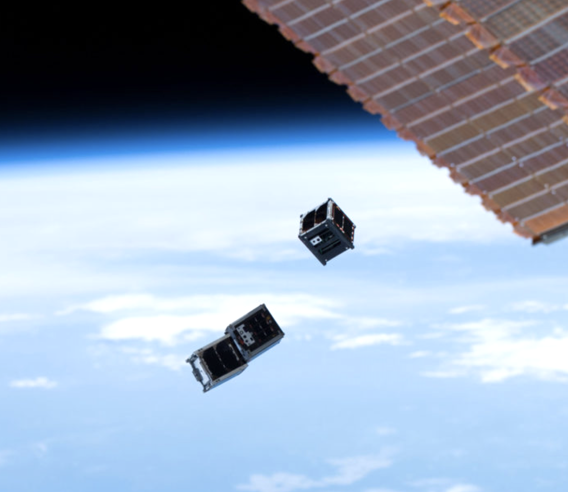
The International Space Station deploys a set of NanoRacks CubeSats. Visual: NASA

These new satellites have the potential to revolutionize many aspects of everyday life — from bringing internet access to remote corners of the globe to monitoring the environment and improving global navigation systems. Amid all the fanfare, a critical danger has flown under the radar: the lack of cybersecurity standards and regulations for commercial satellites, in the U.S. and internationally. As a scholar who studies cyber conflict, I’m keenly aware that this, coupled with satellites’ complex supply chains and layers of stakeholders, leaves them highly vulnerable to cyberattacks.

If hackers were to take control of these satellites, the consequences could be dire. On the mundane end of scale, hackers could simply shut satellites down, denying access to their services. Hackers could also jam or spoof the signals from satellites, creating havoc for critical infrastructure. This includes electric grids, water networks, and transportation systems.

Some of these new satellites have thrusters that allow them to speed up, slow down and change direction in space. If hackers took control of these steerable satellites, the consequences could be catastrophic. Hackers could alter the satellites’ orbits and crash them into other satellites or even the International Space Station.

Makers of these satellites, particularly small CubeSats, use off-the-shelf technology to keep costs low. The wide availability of these components means hackers can analyze them for vulnerabilities. In addition, many of the components draw on open-source technology. The danger here is that hackers could insert back doors and other vulnerabilities into satellites’ software.

The highly technical nature of these satellites also means multiple manufacturers are involved in building the various components. The process of getting these satellites into space is also complicated, involving multiple companies. Even once they are in space, the organizations that own the satellites often outsource their day-to-day management to other companies. With each additional vendor, the vulnerabilities increase as hackers have multiple opportunities to infiltrate the system.

Hacking some of these CubeSats may be as simple as waiting for one of them to pass overhead and then sending malicious commands using specialized ground antennas. Hacking more sophisticated satellites might not be that hard either.

Satellites are typically controlled from ground stations. These stations run computers with software vulnerabilities that can be exploited by hackers. If hackers were to infiltrate these computers, they could send malicious commands to the satellites.

This scenario played out in 1998 when hackers took control of the U.S.-German ROSAT X-Ray satellite. They did it by hacking into computers at the Goddard Space Flight Center in Maryland. The hackers then instructed the satellite to aim its solar panels directly at the sun. This effectively fried its batteries and rendered the satellite useless. The defunct satellite eventually crashed back to Earth in 2011. Hackers could also hold satellites for ransom, as happened in 1999 when hackers took control of the U.K.‘s SkyNet satellites.

Over the years, the threat of cyberattacks on satellites has gotten more dire. In 2008, hackers, possibly from China, reportedly took full control of two NASA satellites, one for about two minutes and the other for about nine minutes. In 2018, another group of Chinese state-backed hackers reportedly launched a sophisticated hacking campaign aimed at satellite operators and defense contractors. Iranian hacking groups have also attempted similar attacks.

Although the U.S. Department of Defense and National Security Agency have made some efforts to address space cybersecurity, the pace has been slow. There are currently no cybersecurity standards for satellites and no governing body to regulate and ensure their cybersecurity. Even if common standards could be developed, there are no mechanisms in place to enforce them. This means responsibility for satellite cybersecurity falls to the individual companies that build and operate them.

As they compete to be the dominant satellite operator, SpaceX and rival companies are under increasing pressure to cut costs. There is also pressure to speed up development and production. This makes it tempting for the companies to cut corners in areas like cybersecurity that are secondary to actually getting these satellites in space.

Even for companies that make a high priority of cybersecurity, the costs associated with guaranteeing the security of each component could be prohibitive. This problem is even more acute for low-cost space missions, where the cost of ensuring cybersecurity could exceed the cost of the satellite itself.

To compound matters, the complex supply chain of these satellites and the multiple parties involved in their management means it’s often not clear who bears responsibility and liability for cyber breaches. This lack of clarity has bred complacency and hindered efforts to secure these important systems.

Some analysts have begun to advocate for strong government involvement in the development and regulation of cybersecurity standards for satellites and other space assets. Congress could work to adopt a comprehensive regulatory framework for the commercial space sector. For instance, they could pass legislation that requires satellites manufacturers to develop a common cybersecurity architecture.

They could also mandate the reporting of all cyber breaches involving satellites. There also needs to be clarity on which space-based assets are deemed critical in order to prioritize cybersecurity efforts. Clear legal guidance on who bears responsibility for cyberattacks on satellites will also go a long way to ensuring that the responsible parties take the necessary measures to secure these systems.

Given the traditionally slow pace of congressional action, a multi-stakeholder approach involving public-private cooperation may be warranted to ensure cybersecurity standards. Whatever steps government and industry take, it is imperative to act now. It would be a profound mistake to wait for hackers to gain control of a commercial satellite and use it to threaten life, limb, and property — here on Earth or in space — before addressing this issue.

By William Akoto, From Undark.org

[The Conversation] William Akoto is a postdoctoral research fellow at the University of Denver.

NASA, New Zealand Partner to Collect Climate Data from Commercial Aircraft


NASA’s CYGNSS missions is installing next-generation Global Navigation Satellite System (GNSS) reflectometry receivers on Air New Zealand passenger aircraft to collect environmental science data over New Zealand. Credit: Air New Zealand

NASA is partnering with the New Zealand Ministry of Business, Innovation and Employment, New Zealand Space Agency, Air New Zealand and the University of Auckland to install next-generation Global Navigation Satellite System (GNSS) reflectometry receivers on passenger aircraft to collect environmental science data over New Zealand.

The program is part of NASA’s Cyclone Global Navigation Satellite System (CYGNSS) mission, a constellation of eight small satellites, launched in 2016, that use signals from Global Positioning System (GPS) satellites that reflect off Earth’s surface to collect science data.

The CYGNSS satellites orbit above the tropics and their primary mission is to use GPS signals to measure wind speed over the ocean by examining GPS signal reflections off choppy versus calm water. This allows researchers to gain new insight into wind speed over the ocean and will allow them to better understand hurricanes and tropical cyclones.

In addition to its primary over-water research capabilities, scientists have discovered that the CYGNSS technology is also capable of collecting valuable measurements over land, including of soil moisture, flooding, and wetland and coastal environments.

“Partnering with New Zealand offers NASA and the CYGNSS team a unique opportunity to develop these secondary capabilities over land. Taken together over time, they’ll also have an important story to tell about the long-term impacts of climate change to these landscapes,” said Gail Skofronick-Jackson, CYGNSS program scientist at NASA Headquarters, Washington.

The CYGNSS team, led by principal investigator Chris Ruf at the University of Michigan in Ann Arbor, has developed a next-generation GNSS reflectivity receiver with support from NASA’s Earth Science Technology Office. These receivers will be installed in late 2020 on one of Air New Zealand’s Q300 domestic aircraft.


In orbit, the CYGNSS mission has eight small satellites flying in formation. They collect GPS signals that reflect off Earth’s surface, which scientists use to infer windspeed over oceans and soil moisture measurements over land. Credits: University of Michigan

As the aircraft traverses New Zealand, it will collect data from the land below, some of which will overlap with the flight paths of the CYGNSS satellites. This overlap, which will have frequent data observations from regular commercial flights, will provide the CYGNSS team a wealth of data to use to validate and improve the CYNGSS satellite observations, said Ruf. In addition, the varied New Zealand terrain will provide comparison points with data collected in similar terrains in other parts of the world.

“As a result of this partnership, both Air New Zealand engineers and researchers across New Zealand will now have the opportunity to work with NASA on a world-leading environmental science mission,” said Peter Crabtree, General Manager of Science, Innovation and International at New Zealand’s Ministry of Business, Innovation and Employment.

The University of Auckland will host the Science Payload Operation Centre, which will begin operations and data collection in late 2020.

“Over time, the data that will be collected by these receivers could form one of New Zealand’s largest bodies of long-term environmental data, and as such it represents a wide range of research opportunities,” said radar systems engineer and project lead Delwyn Moller of the University of Auckland.

Air New Zealand will be the first passenger airline to partner with NASA to collect data for a science mission. Air New Zealand has 23 Q300s in its fleet, and if the approach is successful, the airline will explore introducing the technology more widely.

“As an airline, we’re already seeing the impact of climate change, with flights impacted by volatile weather and storms. Climate change is our biggest sustainability challenge, so it’s incredible we can use our daily operations to enable this world-leading science,” said Air New Zealand Chief Operational Integrity and Standards Officer Captain David Morgan.

NASA uses the unique vantage point of space to better understand Earth as an interconnected system. The agency also uses airborne and ground-based monitoring and develops new ways to observe and study Earth with long-term data records and computer analysis tools to better see how our planet is changing. NASA shares this knowledge with the global community and works with institutions in the United States and around the world that contribute to understanding and protecting our home planet.

For more information about NASA’s Earth science missions

From NASA


NSR Addresses the Butterfly Effect on Smallsats from Starlink’s IPO or is it a Caterpillar?

SpaceX has now launched 242 of the 42,000 total satellites planned for the Starlink constellation, according to their latest filing and it is the largest commercial satellite constellation operating in history, despite having a mere 0.6% of the total in orbit. As a first mover and largest system in the satcom business, Starlink’s future is bound to have a butterfly effect on the rest of the small satellite market by influencing investors’ interest in other missions.

Flap Your Wings

Much like the chaos theory where the butterfly spreading its wings at the Equator can create massive unstable weather systems such as tornados in the U.S. weeks later,  spinning off Starlink for an IPO could lead to such a larger-scale impact on the small satellite market unforeseen.  NSR’s Small Satellite Markets, 6th Edition report assesses over 140 current or planned smallsat constellations. Based on the factors studied , of which the most critical is current funding and the ability to raise money (or lack thereof), it is estimated that 35% of all constellations planned are not likely to launch, with another 5% deemed at low likelihood. Of the constellations expected to launch over the next decade across all applications, Communications will dominate the market by application, with Starlink making up a major portion.

Funding is one of the biggest challenges faced by NGEO constellations, due to the scepticism and uncertainty around the business case. Investors are cautious due to lack of information and understanding about the LEO business model and are holding back until constellations currently in development like Starlink and OneWeb are further along. While OneWeb has been slow to launch and now has 40 satellites in orbit, SpaceX is following a more aggressive timeline to get satellites into orbit to reach the revenue generation stage much quicker and, to increase investors’ confidence in the project. In terms of funding, SpaceX has raised over $1 billion for Starlink. However, the CAPEX associated with manufacturing, launch and serviceability of 42,000 satellites is expected to be orders of magnitude higher than current funding, and while some of it will be recovered by revenues generated by the constellation itself, it is safe to say that it will not be enough to fund the full constellation. Furthermore, SpaceX has maintained to date that the revenues from Starlink will help fund the Starshipproject. So how does the IPO fit into this equation?

Free Cash to Flow?

Taking Starlink public has one obvious advantage — the “free” cash associated with the sales of the stock. While this cuts down the share of Starlink and therefore SpaceX’s share of the profits, the company’s valuation and the value of each share is expected to increase with the IPO, if done right. Two of the most critical factors for the success of an IPO are initial pricing and brand perception. With Elon Musk’s brand and space considered a “sunrise” industry, the latter hurdle can be considered easy to overcome. The stock price is a tricky equation to solve — if the chosen price is too low, it leaves money on the table and if too high, the stock prices can fall quite quickly bruising the company’s reputation. Assuming the shares are priced appropriately, the questions then remain:

Would cash from the IPO be enough to fund the remaining constellation as well as the Mars project?
Is the Offer of Sale (OFS) going to be part of this IPO? That is, will Starlink’s existing shareholder sell a part or all of their shares?
Will there be a follow-on public (FPO) offering? That is, will Starlink issue additional shares at a later stage for further fund raising?

The IPO Impact

At the micro level, if additional funding is required — whether through FPO or equity — and at the macro level to maintain investors’ perception of this market, it would be critical for Starlink to start generating revenues as soon as possible (and in line with their projections at the time of the IPO).

This will help increase Starlink’s market capitalization and therefore its ability to issue more equity shares at relatively high offering prices. And there lies the biggest challenge — revenue and profit generation. A major share of revenues for Starlink is expected to come from government contracts. While that is promising, maintaining a 40,000+ satellite constellation, with competition from terrestrial solutions and potentially other LEO constellations (like Amazon’s Project Kuiper), technical challenges in the ground segment as well as difficulties in obtaining landing rights can severely restrict the revenue and profits from the constellation. Managing the initial and ongoing investor and public expectations will be crucial for the long-term success of the IPO and the company’s valuation and will open investment doors for other smallsat constellations. Even though the business cases, services offered and even the target market may be different for other smallsat constellations, a system like Starlink can be highly influential to sway investors — one way or another. Similarly, if Starlink fails to meet investors’ expectations, it will not only impact Starlink’s valuation and investments in other SpaceX projects, but will also raise more concerns around the constellations business model in general, resulting in a decline in funding for similar projects.

Bottom Line 

It is hard to argue that there is a direct, albeit disproportional, link between the success of the mega constellations and the rest of the small satellite market. Small satellite constellations make up 75% of the overall market (in number of satellites). Amongst the numerous challenges NGEO constellations face including regulatory hurdles, launch and manufacturing constraints, competition, and distribution, the ability to raise funding is a critical determinant of the success or failure of a system — even if only in the short term.

Investors assess various factors before deciding to fund a company, and one of the major considerations is the competition — both as a competitor but also to draw parallels about the market they are thinking about investing into. Elon Musk and the SpaceX brand compounded with the largest and highest risk NGEO constellations has accumulated a lot of interest from investors and any updates — strategic or otherwise — will most definitely have a butterfly effect and impact most future investment in the smallsat market at-large.  

Shagun Sachdeva, NSR Senior Analyst has presented the following

NSR now offers Small Satellite Markets, 6th Edition


Success for PLD Space and the Firm’s Full Rocket Engine Test

PLD Space has successfully achieved a full rocket engine test for the MIURA 1 mission.

TEPREL B is the regenerative engine, designed by PLD Space,that will be used on MIURA 1 flights and is a key milestone in engine qualification campaign, achieving a full-time engine validation on Wednesday, February 26, 2020.

In May of 2019, PLD Space suffered a catastrophic engine failure, which resulted in material damage, including the loss of the first flight version of the TEPREL-B liquid rocket engine, developed by the company for the MIURA 1l launch vehicle. The company then decided to pause the qualification process and analyze the root causes of the failure to solve the problems that were encountered.


Image is courtesy of PLD Space.

After eight months of hard work, PLD Space successfully achieved a full mission duration hot test of the flight engine. This allowed the company to validate the nominal engine performance during the full mission duration burn of two minutes, the necessary time to boost MIURA 1 launch vehicle into space.

Raúl Torres, CEO and Co-Founder of PLD Space, stated that this milestone is a huge step forward for PLD Space, for the Spanish space sector and European small launcher competitiveness and will allow the firm to be one of the few companies in the world that has successfully developed, tested and qualified propulsion technologies for space launch vehicles. Achieving this important milestone implies a turning point in the commercial space race and takes PLD Space step closer in launching MIURA 1 to space. With this result, PLD Space has a rocket engine capable of reaching space soon.

ASU’s Phoenix CubeSat Satellite Launched into Orbit

The ASU Phoenix CubeSat team successfully launched its satellite from the International Space Station on February 19, marking one of the goals in a years-long project by the University. 


Photo by Adrienne Green | The State Press “After over four months of sitting aboard the International Space Station, the spacecraft and its team have been prepared for its launch into low Earth orbit.” Illustration published on Monday, February 24, 2020.

After more than four months of sitting aboard the International Space Station, the spacecraft is now in low orbit close to where it was launched.

Sarah Rogers, project manager of the Phoenix CubeSat and an aerospace engineering graduate student, said the CubeSat was launched from the ISS from a deployer pod and, upon command, was pushed into space using a spring.

Each CubeSat was deployed within an hour and a half of each other to ensure there was enough space between them, Rogers said. 

After it was launched into orbit, the Phoenix team successfully completed their first task, which was hearing the radio waves of the satellite from a ground station. 

Now they are in the operations phase, where they will gather as much information as they can and make sure everything is functioning properly. Rogers said this phase is incredibly “stressful and tricky” because the team has such a short window of communication with the satellite.

“If you can’t fix something within your operations window, you could lose your spacecraft entirely,” Rogers said. 

Going forward, the team will take steps in order to efficiently calibrate the satellite while it is in orbit, said Yegor Zenkov, the lead engineer of the payload team and a materials science and engineering junior.

Zenkov said that because conditions in orbit may vary from the conditions used during the team’s simulated lab, they will compare temperature references, the surface of the ocean and data from weather stations in order to calibrate the satellite.

The team is also working on stabilizing the spacecraft and positioning its solar panels.

“The attitude control system helps control the orientation of the satellite. It will kick in and slow it down to where it can point and orient its solar panels towards the sun,” Rogers said. “It can start generating power from the batteries, which then will supply power to the rest of the spacecraft.”

The ultimate goal of the Phoenix CubeSat is to use images from the satellite to study the Urban Heat Island Effect, which is a phenomenon in which the structure of the city causes a rise in surface temperature. This will allow them to help develop a more sustainable infrastructure for future generations, Rogers said.

Alec Lee Spencer Niblett IV, the science team’s lead and an anthropology senior, is primarily responsible for categorizing and analyzing the urban heat island effect through the images from Phoenix. 

“Different building materials retain thermal energy much longer than natural ground cover,” Niblett said. “So we categorized those different building types.”

When the Phoenix CubeSat stabilizes, it will begin to take photos of various U.S. cities and send the information back. The team will use the images to demonstrate the density of buildings in multiple cities in order to better understand the heat island effect.

“The image will come in packets. Once downloaded, we need to decrypt those packets, which gives us an image,” Niblett said. “(The pictures) will have a data packet that has telemetry information with it, which will say the orientation of the satellite, the inclination, the target point, the altitude and the time and date. It won’t be georeferenced.”

Rogers said she is excited to see the data products that the CubeSat will generate applied to the real world.

“We’re not only benefiting people at this university but other universities as well,” Rogers said.

By Danya Gainor, The State Press

Advantech and TXMission Reveal a Technology and Distribution Partnership 

Combining their talents and business acumen Advantech Wireless Technologies Inc. (“Advantech”), has signed a sales and distribution agreement with the California and Watford, England based TXMission, a designer and manufacturer of high performance SmallSat modems for the New Space Industry. This announcement precedes their participation at Satellite 2020 in Washington, DC, March 10-12 where Advantech Wireless Technologies will be available at booth #1216.

The companies will together develop a comprehensive suite of SmallSat, Airborne and Comms-On-The-Move (COTM) communication products for markets requiring versatile, extremely low size, weight and power (SWaP) products that provide leading-edge performance. The range of fully integrated SmallSat and UAV/Airborne products to be developed will include advanced RF transceivers, multi-gigabit modems for onboard and ground segment applications, low SWaP satellite terminals, antennas, network management systems and 5G technology solutions.

John Restivo, President of Advantech Wireless Technologies is pleased to announce the partnership with TXMission, a professional off-the-shelf, end-to-end satellite communications company.  He said that Advantech plans to integrate their microwave RF technology with the TXMission modem, resulting in a system level solution that will work across multiple Satcom markets. They are certain this relationship will present new opportunities for Advantech.

Steve McHugh, Chairman of TXMission added that this is an exciting development that combines their unique SDR technology with Advantech’s renowned RF capabilities.

Ball Aerospace’s Advanced Spectrometer Instrument Completes PDR for MethaneSAT

Ball Aerospace has successfully completed the preliminary design review (PDR) of the advanced spectrometer instrument for the MethaneSAT Flight System, a 350 kg. satellite that will locate and measure methane emissions around the globe — with the completion of PDR, Ball will proceed with the critical design phase.

MethaneSAT is expected to be launched in 2022 by MethaneSAT LLC, a subsidiary of Environmental Defense Fund (EDF). The non-profit is dedicated to creating innovative science-based solutions to critical environment challenges, including anthropogenic methane emissions, a significant contributor to global climate change.

Two extremely sensitive spectrometers sit at the heart of the Ball-designed instrument that will measure a narrow part of the shortwave infrared spectrum where methane absorbs light, allowing it to detect concentrations as low as two parts per billion. In addition to the MethaneSAT instrument, Ball Aerospace is providing flight systems integration and testing, launch support, and commissioning services.


Artistic rendition of the Environmental Defense Fund’ MethaneSAT.

Dr. Makenzie Lystrup, VP and GM, Civil Space, Ball Aerospace, said the firm is excited to be a part of a mission that aims to study and address the impact of methane on the environment and climate. MethaneSAT fits well with Ball’s long history of Earth science.

Mission co-lead Dr. Steven Hamburg, who also serves as Chief Scientist for Environmental Defense Fund, noted that MethaneSAT is built around a set of high performance technologies and sophisticated analytics tools that, when combined, provide a major leap in the ability to measure and quantify even low-level methane emissions across the globe from space. A lot is being asked of the technical partners and Ball Aerospace is rising to the occasion.

Altitude Lowering Underway for ALE’s Shooting Star Efforts

ALE Co., Ltd.(ALE), led by CEO Lena Okajima, has reported that the company’s first man-made shooting star satellite that was launched on January 18, 2019, has begun its mission to lower its altitude.

ALE-1, the first satellite jointly developed by ALE and National University Corporation Tohoku University (Tohoku University) to try to create a man-made shooting star, was launched on January 18, 2019, on the JAXA Innovative Satellite Technology Demonstration-1 (Epsilon Rocket No. 4) with six other satellites and was placed into orbit at an altitude of about 500 km.

The operating altitude for releasing particles to create man-made shooting stars is targeted for about 400 km., which means the satellite will need to lower its altitude for about 100 km. to a required altitude for operation.

A thin film orbit release device, DOM®: De-Orbit Mechanism (DOM®), jointly developed with Nakashimada Engineering Works, Ltd. and Tohoku University, that is attached to the satellite is used to lower the altitude gradually using atmospheric drag.

ALE-1 will reach the altitude of 400 km. in about one year and, after technological verification, it will begin its emission operation of the man-made shooting stars.


This ALE-1 satellite photo is courtesy of the company.

Change in schedule of altitude descent

At the time of its launch, ALE-1’s altitude descent was originally planned to start from March of 2019; however, due to additional post-launch trials, detailed orbit data collection and technological verifications for the use of second satellite (ALE-2) operations, the starting date for ALE-‘s altitude descent was postponed.
     After the initial trials, completion of data accumulation, and technological verifications for ALE-2 operations, the DOM® thin film unfolded on December 25, 2019, and ALE-1’s altitude started to descend. The results from monitoring orbit transition for one month confirmed that the speed of altitude descendant of ALE-1 has accelerated.