Sen’s UHD Space Videos to be Filmed, Per Contract, by NanoAvionics’ SmallSats

Sen, a British space company that is establishing a video streaming media to provide real-time and timely Ultra-High Definition (UHD) video of Earth, has contracted NanoAvionics to build the first five smallsats of its constellation.

Sen has already demonstrated its technology of streaming ultra-high definition (UHD) video from space and is now focused on developing its “EarthTV” constellation of smallsats to stream real-time and timely videos from space. The service, which will include a freely accessible app for individuals, will be used for monitoring environmental events and natural disasters such as wild fires, floods and storms, as well as monitoring climate change and movement of large groups of people.

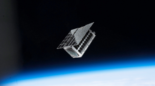
As the start of Sen’s mission to create its “EarthTV” constellation, NanoAvionics will build the 16U smallsat buses and integrate Sen’s payload at their European manufacturing and research facility in Vilnius, Lithuania.

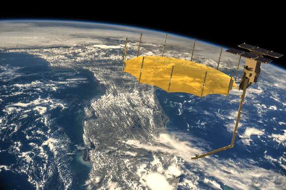
Each satellite will be equipped with several UHD cameras, providing multiple perspectives of Earth, from wide angle imagery down to 1.5 meter resolution. The envisaged launch of the first smallsat, EarthTV-1, will take place by mid-2021. Following a successful test demonstration of EarthTV-1, sending real-time UHD quality video from LEO, NanoAvionics will build the remaining four smallsats for launch in 2022.

NanoAvionics standardized flight-proven nano-satellite buses use modular software approach and flexible architecture with a single fault tolerant design option. By doubling the critical satellite subsystems, single point failures are removed from the system, hence adding mission reliability and redundancy. Such satellite system is designed to have a mission lifetime of 10 years in LEO. These features have allowed the company to increase the range of capabilities offered for a payload, making them ideal to host Sen’s video cameras and video streaming system.

Founded in 2014, Sen already demonstrated 4K Ultra High Definition video from a satellite with six cameras during its first mission which launched in February 2019, filming both the satellite and wide-angle imagery of Earth with its steerable cameras. Sen’s videos will be freely accessible for individuals, with premium services for businesses and organisations.

Sen will provide an open source data platform to enable partner organizations to build apps and analytics using the video data. Sen aims to begin with cameras in LEO and plans to extend this to deeper space and even to deploy cameras on planetary orbiters, rovers and drones at the Moon, Mars and further into the Solar System.

Charles Black, Founder and CEO of Sen, stated that this planet is constantly changing and Sen’s satellites will provide a new and persistent way of seeing events unfolding, empowering humanity to witness the evolution of our planet in a unique way. The company hopes to increase awareness of environmental events and human movement with information that can educate, inspire and empower people to change and improve the outcome. Sen is delighted to be working with NanoAvionics. They have a great team of engineers, first class facilities and a successful track record of building nano-satellites. The firms’ teams have worked extensively together over the last six months to ensure the satellite bus will meet the firm’s specific requirements for streaming high definition videos from several cameras.

Vytenis J. Buzas, Co-Founder and CEO of NanoAvionics, said that building a real-time video service in space is a fantastic mission and shows the growing capabilities of nano-satellites. The company has scaled its flagship, preconfigured, M6P bus to achieve 12U and 16U form factors and to provide customers such as Sen with more possibilities for their missions and payloads. These scaled-up versions have already become NanoAvionics’ most sought-after products and main workhorses in enabling innovative satellite missions in LEO.


L3Harris Showcases the New Smallsat Reflector Antenna at DC Show

L3Harris Technologies (NYSE:LHX) has introduced a new, smallsat reflector antenna that will help decrease the size, weight and overall time to produce smallsats. L3Harris will showcase this  reflector antenna in booth 601 at the SATELLITE 2020 conference March 9-12 in Washington, D.C.

Lighter and more compact than legacy designs, the new Smallsat Perimeter Truss (SPT) leverages L3Harris’ advanced Perimeter Truss design, while optimizing its mass to make the unit lighter and smaller to package onto small satellites.

Offered in diameters up to four meters, and specifically designed for use on smallsat platforms, the Ka-band SPT is one-third the size and 50 percent the weight of previous designs. When stowed, the reflector is about the size of a commercial office fire extinguisher.

Ed Zoiss, President, Space and Airborne Systems, L3Harris, reported that smallsats are playing a more important role in space and industry must continue to develop ways to make every satellite component smaller and lighter to keep pace with production and mission requirements. L3Harris has done that with the new Smallsat Perimeter Truss — enabling the company to package large high-gain antennas onto smaller satellite platforms. 


A Conversation with … Charles Miller, CEO, Lynk


Charles Miller

Charles Miller is the Co-Founder and Chief Executive Officer of Lynk.  He is a serial space entrepreneur with 30 years of experience in the space industry, and  has been the founder or co-founder of multiple private ventures and organizations. He is a national leader in the creation and development of public-private partnerships in commercial space to serve public needs.
     One of Charles’ previous startups is NanoRacks, which has delivered more than 700 payloads to space and is the current world leader in smallsat launches. Charles served as NASA’s Senior Advisor for Commercial Space from 2009-2012 where he advised NASA leadership on commercial public private partnerships.
     At NASA, he managed USG teams that developed strategies for commercial development of reusable launch vehicles, on-orbit satellite servicing, orbital debris removal, microgravity applications, lunar development, space communications, and space solar power. Charles’ clients have included NASA, DARPA, the USAF, and many private commercial space firms.

Good day, Mr. Miller… please tell us about Lynk.

Charles Miller (CM)
Lynk has developed a breakthrough technology that will provide connectivity for cell phone users virtually anywhere on the globe using a network of Low Earth Orbit (LEO) smallsats. This includes providing a safety net for people working or traveling in remote locations and giving relief agencies and first responders a highly reliable means of communication when responding to natural disasters.  

How does the firm’s technology work?

CM
Cell phones connected to terrestrial towers generally have a range limited to around 35 kilometers if the line-of-sight is not interrupted by hills, buildings, or foliage. The signal can travel much further, but the reception range is artificially limited by the highly accurate time frames of the cell phone protocol.
     However, with Lynk’s patented technology, the phone signal can reach a satellite flying across the sky in a 500-kilometer altitude orbit. Our satellites are sensitive enough to connect to the phone for text messages and voice calls using standard cell phone protocols.
     Lynk’s technology allows standard cell phones, without any changes in hardware or software, to be connected anywhere on the globe using LEO smallsats.

How will this service be delivered to users?

CM
Lynk has signed trial agreements with 30 partners, including 21 Mobile Network Operators (MNOs) representing approximately 1.1 billion mobile phone subscribers. The service will be sold to phone subscribers through their MNOs. We want to make the experience as seamless as possible to the end user.
     You will have one phone, and one phone plan. When you roam on to our “cell network in space,” the charges will show up on your existing plan at the end of the month.

What is the ultimate goal of Lynk?

CM
Our goal is to provide everyone, everywhere, mobile connectivity.
     When hurricanes take out the phone towers, there will be immediate and instant backup for emergency responders to come save you.
     When fires or tornadoes threaten to destroy your community in a remote area, you and your family will receive timely notice of the threat and be given effective directions on what you need to do.
     When your truck, boat, ATV, or snowmobile breaks down in a remote area, or you break your leg while hiking in the mountains, you will always be able to call for help. Nobody should ever die because they have a phone in their pocket that was not connected.

lynk.world


Hughes Network Systems Becomes Worldwide Distribution Partner for OneWeb

Hughes Network Systems, LLC (HUGHES) and OneWeb have announced that Hughes has become a worldwide distribution partner for OneWeb.

OneWeb’s constellation of LEO satellites will expand Hughes service offerings and ensure that the company’s customers can access low-latency, high-speed connectivity, wherever they are located. Applications will include enterprise and government networking, cellular backhaul and community Wi-Fi hotspots.

The new agreement expands an already successful relationship between the two companies. Hughes is an investor, through its parent company EchoStar, and an ecosystem partner to OneWeb, helping to develop essential ground network technology for OneWeb’s LEO system.

OneWeb works with carefully selected distribution partners in each of its core markets, providing new business and expansion opportunities through the low latency, global, high throughput attributes of OneWeb’s network.

OneWeb is building its initial constellation of 650 LEO satellites. By late 2021, OneWeb will be offering low latency globally, with the same capacity over the water, in the air, in previously unconnectable places and everywhere else.

Service testing on the satellites already on-orbit is underway, using gateways that Hughes is building for the network. Results are positive, including seamless satellite and beam handovers, high speeds and low latency.

The gateways feature multiple tracking antennas to support operation and handoff of high-speed user traffic to and from the LEO satellites, and can handle up to 10,000 terminal hand-offs per second – a technological and engineering breakthrough. Every OneWeb terminal, whether for fixed or mobile services, will incorporate a core module, including modem, developed and manufactured by Hughes.

Pradman Kaul, President, Hughes, said a new era of global connectivity demand is being entered, one that can only be fulfilled by a mix of data transport services, including terrestrial, geostationary and LEO satellites. OneWeb complements the company’s service portfolio with a truly global coverage, low-latency option that will enable the customers to meet their end users’ needs for connectivity everywhere.”

Adrian Steckel, CEO, OneWeb, related that connectivity is only truly valuable when it delivers the user experience that customers need, and in today’s fast-moving digital economy, businesses and civil government organizations need high quality, continuous internet access wherever they are located. The company is delighted that Hughes is joining OneWeb on the firm’s mission to deliver this vision. Hughes is already an important investor and an invaluable technology partner. 

Hughes is exhibiting at SATELLITE 2020, March 10-13, at the Walter E. Washington Convention Center in Washington, D.C., and is showcasing how consumers, businesses, governments and communities around the world benefit from the connected experiences enabled by Hughes technologies and services. Please visit www.hughes.com/sat20

New Modem Chip for LEO, MEO and GEO from SatixFy

SatixFy Space System has announced a new modem chip to be used over LEO, MEO and GEO systems, with appropriate doppler and fade profile performance.

The Sx3099 hosts 1 to 8 modems with aggregated throughput of 1 Gsymb/sec in both Tx and Rx directions. A single Sx3099 chip provides a single 1 Gsymb/sec carrier 2 X 500 Msymb/sec “make before break” handover in LEO aero connectivity, 8 X 125 Msymb/sec or any combination of channels aggregated to 1 Gsymb/sec.

This is the first chip to fully support the entire DVB-S2X standard including all Beam Hopping modes as defined in the 2019 revision annex E. On top of previously defined formats, the chip includes all the new Super-frame format types 5, 6 and 7 (“point and shoot” Beam Hopping). Sx3099 includes native support for DVB-RCS2 400MHz transmission as well as complete Software Defined Radio (SDR) for any other waveform.

Rocket Lab to Launch Capella Space’s First SAR Satellite

Rocket Lab has inked a deal to launch a dedicated mission for Capella Space, an aerospace and information services company that provides Earth observation data on demand.

Capella Space and Rocket Lab will launch the first synthetic aperture radar (SAR) satellite that delivers commercial data into a mid-inclination orbit to optimize hotspot monitoring of key regions in the world.


A Rocket Lab Electron launch vehicle on its launch pad. Photo is courtesy of the company.

Launching later this year, the mission will loft the first satellite of Capella Space’s Whitney constellation on an Electron launch vehicle from Rocket Lab’s Launch Complex 1 on New Zealand’s Mahia Peninsula. By positioning the satellite to a 45 degree inclination, Capella Space will maximize coverage over important areas such as the Middle East, Korea, Japan, South East Asia, Africa and the U.S.

This launch paves the way for reliable and persistent imagery of anywhere on the globe, day or night, and in any weather conditions. Capella’s space-based radar can detect sub-0.5 meter changes on the surface of the Earth, providing insights and data that can be used for security, agricultural and infrastructure monitoring, as well as disaster response and recovery.


Capella Space SAR smallsat to Deliver high resolution, on-demand EO data. Artistic rendition is courtesy of the company.

Capella Space will be the primary payload on the Electron launch vehicle, enabling Capella to select a specific orbit and launch timeline to meet its customer needs in terms of coverage, revisit and image quality.

While the Capella Space mission is scheduled for mid-2020, Rocket Lab’s next Electron launch will be on the pad at Launch Complex 1 in late March. Details of the next mission and customer will be released in the coming week.

Payam Banazadeh, CEO of Capella Space, said the company helps customers solve some of the world’s biggest and most complex problems – from climate change to infrastructure monitoring – using on-demand, accurate, Earth Observation data. Launching the firm’s first Whitney satellite on a dedicated Rocket Lab mission allows Capella Space to stay in control of the firm’s orbit and focus on the goal of delivering customer-focused solutions in a timely manner.

Rocket Lab Founder and CEO, Peter Beck, added that this dedicated launch solution will get Capella Space on-orbit faster, enabling them to focus on their core mission – providing reliable, up to the hour imagery data to inform everyday decisions on Earth. By launching on Electron, the team at Capella are in control of their mission every step of the way. The ability to book a launch quickly, have control over launch timing and select an exact orbit puts customers like Capella in the driver’s seat as they build out their constellations how and when they want to.


UPDATED: Isotropic Systems and SES Driving Customer Edge Terminal Development

Isotropic Systems and SES have initiated a new developmental phase of their collaborative partnership to produce scalable, cost-effective, multi-beam, customer edge terminal antennas capable of unlocking access to the groundbreaking O3b mPOWER system across government and defence, telco and cellular backhaul, aero, maritime, and offshore markets.


Isotropic and SES customer edge terminal.

Together with SES, Isotropic Systems will review, refine, and test key components of its full line of customized digital software-defined terminals throughout 2020, optimizing the tiered platform to meet specific performance, cost, power, and connectivity requirements of user cases around the world. The development roadmap will culminate in a series of comprehensive engineering evaluations of Isotropic Systems’ multi-beam antenna components, prior to the commercial launch of the customer edge terminals and the O3b mPOWER MEO system in 2021.


Artistic rendition of SES’ O3b mPOWER constellation on-orbit. Image courtesy of the company.

Many of the upcoming trials — the first underway this month — will focus on maximizing the effectiveness of the circuits behind the optical beam-forming lens modules at the core of the Isotropic Systems adaptable multi-beam antenna. The patented lens module technology is a major differentiator, enabling seamless switching between SES’s multi-orbit fleets, and opening the door to a new age of widely accessible and tailored high-performance Ku- and Ka-band connectivity.

SES and Isotropic Systems first announced their partnership in 2018 when SES contracted Isotropic Systems to develop smart, high-throughput customer edge terminal solutions for the O3b mPOWER system. The fully funded, next-gen and highly flexible MEO satellite-based data communications system is a scalable terabit-level constellation supporting thousands of dynamic beams, and exponentially expands SES’s first-generation O3b MEO system capabilities to deliver a whole new level of customization.

Stewart Sanders, SES’s EVP and O3b mPOWER Program Lead, stated that the SES-Isotropic Systems partnership is driving the development of innovative multi-beam customer edge terminal antennas using digital beamforming that will light up new market opportunities for the tailored scalability and flexibility of our O3b mPOWER network and the company’s unique multi-orbit, MEO-GEO constellations. The firms’ shared vision is keenly focused on bringing game-changing, high-performance broadband to both highly sophisticated and mass markets across the globe, on land, at sea, and in the air.

John Finney, Founder and CEO of Isotropic System, said the Isotropic Systems multi-beam antennas, featuring the firm’s patented, optical, digital beam-forming lens technologies, provide the high-throughput ground infrastructure required to unlock a new wave of HTS constellations, including SES’s high-performance, multi-constellation, satellite networks across a wide range of markets. The Isotropic terminals are customizable to meet the performance, cost, and power requirements of countless applications – from the most complex government defence systems and mobile backhaul solutions capable of extending 5G, to next-gen connected experiences aboard commercial airliners, cruise ships, offshore rigs, and even small fishing boats at sea.

Isotropic Systems will showcase a mockup of the customer edge terminal antenna at the Satellite 2020 Conference and Exhibition at the Washington Convention Center on March 9-12 in Washington, DC.

China’s MinoSpace Commercial Satellite Firm Closes on Millions in Funding

Beijing-based private commercial satellite company MinoSpace has closed their Series A2+ round, collecting nearly RMB 100 million ($14.2 million), led by investment firm Billionhome Capital.

The new funds will serve to develop satellites weighing more than 200 kg. — the firm has already launched four satellites into orbits during 2019, making MinoSpace one of the pioneers in China’s burgeoning private aerospace sector.

The recent round comes after the company scored an investment worth “tens of millions of yuan” in its Series A+ round in September 2019.

MinoSpace, which was established in 2017, produces communication satellites and satellite components, and is also engaged in the development of a smallsat platform and a satellite communication ground terminal.

More than 141 commercial aerospace companies had been registered in China by the end of 2018, following a late 2014’s central government policy which opened the space to private capital to boost the satellite sector development in China.

Article source: KrASIA, by Song Jingli

China’s Largest Private Automaker is Building a Satellite Network Now, Too

The largest private automaker in China is getting into the satellite business. Chinese automotive giant Geely has broadened its reach to include everything from trucking, to high-speed trains, to passenger drones, to Volvo over the last decade or so. But its newest effort could tie those things all together, as Geely just announced it’s going to build its own satellite network to enable what it calls a “smart three-dimensional mobility ecosystem.”

Geely announced late Monday that it will erect a satellite production facility and testing center in the port city of Taizhou in the Zhejiang province that the Chinese giant calls home. The facility will be capable of building a “variety of different satellite models,” some of which may be for non-Geely entities.

Geely says it will start launching the satellite network as soon as the end of this year, but did not say how big it will be. Reuters reports that the company is pumping around $326 million into the project, and will eventually make 500 satellites a year. 

These low-orbit satellites will support high-speed data transmission, precise navigation, and cloud computing, Geely says, and will enable fast over-the-air updates to its vehicles, as well as “content delivery” to the company’s owners. It doesn’t appear that Geely wants to open up the its satellite constellations that SpaceX and OneWeb are building, and it doesn’t appear that these satellites will be used for standard internet connections.

The navigation piece of the equation could be particularly helpful, Geely says, since current GPS satellites are only accurate to several meters thanks to their high orbits. Low-orbit satellites, Geely claims, can be accurate to within a centimeter. “This accuracy is not only important for cars, it will also become essential for unmanned flight,” a company representative said.


A rendering of Geely’s production facility in Taizhou, China. Image: Geely

If and when the world ever starts to fill up with autonomous cars, the demand for in-car connectivity could stretch far beyond what it is today. Having your own satellite network to back up that demand could be a crucial advantage over competitors, then. Wall Street analysts have even repeatedly asked Tesla CEO Elon Musk about this as his other company, SpaceX, started building out its Starlink satellite network. Musk has said in the near term, though, that he doesn’t see an advantage in fitting Teslas to be able to work with Starlink satellites because the hardware required would be too big on the car. 

“The antenna for that high-bandwidth, low-latency [connection] is sort of about the size of medium pizza, which you could put on a car, but I think is more bandwidth than you would really need,” he said in January. That said, Musk admitted “it’s certainly something that could happen in coming years.”

By Sean O’Kane, TheVerge

PredaSAR Names Retired USAF Maj. Gen. Teagu to Lead Constellation Development with $25 Million Seed Financing 

PredaSAR Corporation (“PredaSAR” or “the Company”) announces that the company will build and operate the largest and commercially advanced Synthetic Aperture Radar (SAR) satellite constellation, after successfully completing a $25 million seed financing round.


Major General (Ret.) Roger W. Teague

Funds were raised from a diverse network of global institutional investors, including Miami-based lead investor, Rokk3r Fuel. The Company also named retired Air Force Major General Roger W. Teague as Chief Executive Officer, effective immediately.

SAR is an advanced form of radar used to create 2-D images or 3-D reconstructions of objects. Overcoming the limitations of traditional optical satellites, SAR provides high-resolution images, regardless of time of day or weather conditions.

Recent advancements in engineering, manufacturing and the way SAR data is collected and processed, has resulted in decreasing the size, weight, power consumption and cost of SAR systems.

At the same time, the capabilities of SAR have increased so that data can be sent to the ground in virtual real- time to support mission-critical commercial and military applications.

Marc Bell, PredaSAR Chairman and Co-Founder, said there is an ever-increasing demand for low-latency SAR data. PredaSAR’s pending constellation will feature constant image capture to end-users, resulting in the most powerful small satellite SAR system ever delivered, that is well-ahead of other satellite technology. Proceeds from the raise will be used to manufacture and launch two SAR satellites through a strategic partnership with Tyvak, a leading innovator and provider of smallsats. Tyvak’s broad range of end-to-end satellite knowledge and expertise will boost PredaSAR’s capabilities and empower the Company to establish a strong foundation.
     Bell added that with more than 30 years of distinguished service to the nation while serving in the U.S. Air Force, Maj. Gen. Teague has been tasked with guiding a trusted and experienced executive team, and brings a wealth of national security space expertise and demonstrated excellence to PredaSAR. From guiding the Space Based Infrared Systems (SBIRS) program to first launch, to helping The Boeing Company secure a number of recent big wins in their space communications portfolio, PredaSAR is fortunate to have such an experienced individual at the helm of the company.

Jeff Ransdell, Founding Partner and Managing Director of Rokk3r Fuel, said the company is proud to be part of the PredaSAR journey. The company’s vision and business model aligns exactly with the firm’s intent to support entrepreneurs with groundbreaking ideas propelled by exponential technologies that have the potential to change the world. PredaSAR is an absolute game-changer in its space.

Teague commented that he is proud to lead the PredaSAR team — the company has been carefully planning and developing the best commercial SAR satellite system capabilities, while building an incredible leadership team. The firm is completely focused on the intent to clearly observe the surface of the Earth, anywhere and at any time, so that the company can provide actionable data to government and commercial customers.

Major General Roger Teague was commissioned in 1986 as a graduate of the U.S. Air Force Academy. His career included a broad range of assignments primarily acquiring, operating and supporting space systems. Among his important assignments, he commanded the 4th Space Operations Squadron, where he led his unit during launch, test and operational activation of three Milstar communications satellites. He also served as the Director, Space Programs, Office of the Assistant Secretary for Acquisition in Washington, D.C. For Teague’s distinguished military background, access this direct infolink.