Satellite Map of Queensland, Australia, Completed for the Third Time by Earth-i

Earth-i has completed the third annual update of the satellite map of the state of Queensland, Australia.

The map covers the entirety of Queensland’s 1.9 million km2 and was created by Earth-i for the Department of Natural Resources, Mines and Energy (DNRME). The first map was produced in 2016, with Earth-i reappointed for updates in both 2017 and 2018..


Earth-i image captures of Queensland, Australia.

Around 6,000 very high-resolution images from the DMC3 Constellation were used for the 2018 update of the map with multiple re-visits to tropical areas with heavy cloud cover. The images have a pixel size of 80 cm. (one pixel equates to 80 cm. on the ground) so that details, such as individual trees, can be easily seen.

All three maps are available on an online portal — ‘The Queensland Globe’– where images can be viewed and printed. They are used by a variety of Government departments, local agencies and natural resource management groups to manage and monitor Queensland’s resources and improve policy development, investment and planning decisions. The map also helps to monitor environmental changes, and helps with the planning of long-term land development strategies.

Earth-i faced strong competition to lead this prestigious project which has set the standard for Governments across the world who are looking to use images of Earth taken from space to improve their decision-making. As qualified suppliers to other states in Australia, Earth-i is helping Australia retain its position as a leader in the development of geospatial data infrastructure which is driving both economic development and good environmental management.

Executive Comments

Steve Jacoby, Executive Director of Land and Spatial Information at the Queensland Department of Natural Resources, Mines and Energy, said that Earth-i is an innovative company that combines quality images and analysis with excellent service. The Queensland Globe is very well used and helping to improve the decision making of a wide variety of organizations.

Paul Majmader, Commercial Director of Earth-i, added that winning this contract for the third consecutive time is a tribute to the company’s entire team. The DNRME in Queensland is showing Governments around the world how important regularly updated, high resolution data is in making informed policy decisions.


Contract Initiated Between Momentus and EXOLAUNCH for SmallSat LEO Support

Momentus, a provider of in-space transportation services, has announced that the company is taking orders for their Vigoride and Vigoride Extended services (orbital repositioning for satellites with masses up to 250 kg.) and have signed their first customer — EXOLAUNCH — in a contract worth more than $6 million. EXOLAUNCH (formerly ECM Launch Services) is a leading European launch services provider and cluster integrator that will first use Vigoride in the fourth quarter of 2020 and Vigoride Extended in 2021.

A graduate of the Y combinator program and based in Santa Clara, California, Momentus is currently perfecting both Vigoride and Vigoride Extended to perform last-mile delivery in space for payloads up to 250 kg. Prospective customers can download the Vigoride services datasheet to determine if Vigoride is correct for their needs.

The Vigoride service is designed to support smallsats and cubesats in LEO. Vigoride Extended is capable of delivering smallsats throughout HEO and MEO, including GEO, Lunar orbit, and beyond. Momentus employs new and proprietary technology including water plasma engines for the mission of low cost sustainable transportation though space. Vigoride and Vigoride Extended are the first two offerings in a pipeline of planned Momentus services that will grow over time to be capable of repositioning multi-ton payloads from low Earth orbit to many different destinations, including geosynchronous orbit, the Moon, and interplanetary transfer.

Executive Comments

Dmitriy Bogdanov, CEO of EXOLAUNCH, said “EXOLAUNCH has booked Momentus’ in-space transportation services to provide our clients a unique and effective orbit transfer service. The Vigoride service will be used to deploy CubeSat and micro satellite constellations to multiple orbits, giving clients an unprecedented flexibility of satellite deployment, reducing the price of launch, and giving access to orbits not typical for ridesharing vehicles as early as next year. The company also plans to deliver smallsats to GEO using the Vigoride Extended service. Momentus will enable the firm to service a larger segment of the market by enabling customers to reach custom orbits in an efficient and cost-effective manner.

Momentus CEO Mikhail Kokorich added that the company designed Vigoride to put a client’s satellites exactly where they need to be in space. The company is delighted to be partnering with such a pioneering and innovative company as EXOLAUNCH to show the first value proposition of the Momentus product chain.


“Momentus uses radical innovation, agile development methods, breakthrough technology, and practical manufacturing methods to dramatically reduce cost and improve performance. Our customers are very excited about the resulting cost savings and mission benefits we can provide.”, said Momentus CTO Dr. Joel C. Sercel.

The first leg of a satellite’s journey will include a ride along with Vigoride on a rideshare on a large rocket, a dedicated small launch vehicle, or deployment from the International Space Station. The Vigoride transfer vehicle then carries a satellite, or constellation of satellites, through space to their final destination orbits. The Vigoride service is infinitely flexible and can deploy up to dozens of individual satellites in custom orbits as part of a single mission.

Growth in the small satellite market continues to accelerate driving demand for the services Momentus has pioneered. The total number of satellites deployed to low Earth orbit is projected to grow from the under 3,500 that have been launched in the past two decades to several thousand within the next five years. With the Vigoride service available for customer orders now, Momentus has achieved unprecedented performance and safety at an unbeatable cost. With limited availability, customers will be serviced on a first come first serve basis.

Orbital AI is the Stated Goal of Hypergiant Industries as the Company Launches Their Galactic Systems Division

Hypergiant Industries has announced the launch of their Galactic Systems division, with the goal of helping mankind expand its horizon into the next frontier through orbital AI.

Hypergiant Galactic Systems will focus on artificial intelligence-driven aerospace and astronautic software and hardware products for the booming space industry.

In its first step toward realizing this vision, Hypergiant Galactic Systems has acquired Satellite & Extraterrestrial Operations & Procedures (S.E.O.P.s), a Houston-based satellite deployment and services provider that offers innovative proprietary launch and deployment systems servicing the CubeSat and smallsat markets.

As a subsidiary of Hypergiant Galactic Systems, S.E.O.P.s will continue to serve customers in defense, government, as well as leading academic institutions in designing, developing, and deploying space satellite constellation arrays. S.E.O.P.s operates classified missions as well as unclassified missions for customers and partners including NASA, DARPA, and Northrop Grumman. S.E.O.P.s currently has allocation on all ISS visiting vehicles (SpaceX Dragon and Cygnus) through its partnership with the Center for the Advancement of Science in Space (CASIS).

S.E.O.P.s is led by CEO Chad Brinkley and CTO Michael Johnson. A space entrepreneur with nearly 20 years of experience in the Aerospace and Defense market, Brinkley’s expertise spans the government, military, and commercial sectors. On the technical side, Johnson is the industry leader in designing space research platforms, habitats, modules, launch systems, and spacecraft. He was previously the co-founder of NanoRacks, the first commercial space company to launch CubeSats using the International Space Station (ISS). To date, more than 210 CubeSats have been deployed, fueling the rise of commercial space investments. Both Brinkley and Johnson will continue to lead as CEO and CTO of Hypergiant S.E.O.P.s, a subsidiary of Hypergiant Galactic Systems.

S.E.O.P.s became a leader over the last decade in the industry by flying satellites and payloads to LEO, using deployment off the International Space Station (ISS), as well as using ISS visiting vehicles. The S.E.O.P.s Slingshot CubeSat launch system was designed to exploit the unused Cygnus vestibule volume of the passive common berthing mechanism (PCBM) by deploying sideways using a zero tip-off mechanism. SlingShot Deployers accommodate any customer’s CubeSat formats and configurations. The system can also fly hosted payloads using the core spacecraft for data, power, pointing, and communications. According to the company, no other system provides comparable space agility. By working with Northrop Grumman, CASIS, and the U.S. National Laboratory, S.E.O.P.s is executing on the vision of the commercialization of space for industries spanning defense, energy, security, and more.

S.E.O.P.s’ proprietary sideways deployment also makes it possible to mount SlingShot deployers on a geosynchronous satellite bus, such as a Boeing 702 or Lockheed 2100, opening small satellite deployment in the GEO belt. Furthermore, S.E.O.P.s has been testing its MicroSat solution (MACE), which is planned to come online in 2019 to deploy larger spacecraft.

Hypergiant Galactic Systems is a subsidiary of Hypergiant Industries, the first machine intelligence industrial complex, recently co-founded in Texas by Ben Lamm. Leveraging emerging technology in AI, space transport, and imaging techniques, Hypergiant Galactic Systems is completing the vision of a universe intelligently powered. Hypergiant Galactic Systems will be based in Houston, Texas, with a field office in Washington D.C.

Executive Comments

Ben Lamm, CEO of Hypergiant, welcomes S.E.O.P.s to Hypergiant Galactic Systems. S.E.O.P.s will be the firm’s key entry platform for intelligent satellite technologies. The company’s first day of operation offers world-class launch and deployment capabilities for anyone seeking solutions for LEO and beyond. The fully realized potential of space lies at the intersection of data, AI, and other machine-intelligent technologies..

Chad Brinkley, CEO and co-founder of S.E.O.P.s, noted that in joining Hypergiant Galactic Systems, the company has gained access to invaluable resources in artificial intelligence, machine learning, intelligent sensors, and more. As S.E.O.P.s leverages these technologies to enhance the firm’s offerings and develop entirely new services, customers will be delighted by the new value created through data and machine learning. Today is a great day for space science.

NOTE: All imagery in the above story are courtesy of John Davidson.

Canadian Government Bestows Arctic Surveillance SmallSat Contract Upon Space Flight Laboratory

 
The Canadian Department of National Defence has awarded a C$15 million contract to Space Flight Laboratory (SFL) at the University of Toronto Institute for Aerospace Studies (UTIAS) for development of multipurpose smallsats to support Arctic surveillance — upon successful completion and testing of the prototype, two additional smallsats will be built to create a small formation.

 
On behalf of Defence Minister Harjit S. Sajjan, Member of Parliament for York Centre, Michael Levitt announced the contract on February 1, 2019, during a ceremony held at UTIAS in Toronto. The contract was awarded through Public Services and Procurement Canada under the All Domain Situational Awareness (ADSA) Science & Technology (S&T) Program.
 
The UTIAS SFL smallsats being developed will include multiple sensors on a constellation operating in close formation in LEO to allow for quick and timely detection and identification of surface or airborne targets. These concurrently-obtained sensor observations are expected to improve the reliability of the detection and identification performance, which is not feasible when individual sensors are located on non-collaborating satellites.


The GHGSat-3 smallsat. Photo is courtesy of UTIAS-SFL.

Established in 1998 as a self-sustaining specialty lab at the University of Toronto Institute for Aerospace Studies (UTIAS), SFL has built more than 25 smallsats with more than 95 cumulative years of successful operation on orbit. SFL’s attitude control technologies have also been applied successfully in several other microspace programs as well, including the 2016 GHGSat-D greenhouse gas emissions monitoring satellite and the 2013-2014 BRITE space astronomy constellation.


A BRITE smallsat… The BRITE Constellation will monitor for long stretches of time the brightness and color variations of most of the brightest stars visible to the eye in the night sky. These stars include some of the most massive and luminous stars in the Galaxy, many of which are precursors to supernova explosions. 
Photo is courtesy of UTIAS-SFL.

As outlined in its defence policy Strong, Secure, Engaged, the Department of National Defence is investing in defense research and development to produce innovative solutions to surveillance challenges in Canada’s North, particularly in the priority areas of Arctic joint intelligence, surveillance and reconnaissance. Surveillance solutions support the Canadian government’s ability to exercise sovereignty in the North and provide a greater awareness of safety and security issues, as well as transportation and commercial activity in Canada’s Arctic. In addition, solutions achieved under the ADSA program will contribute to joint efforts between Canada and the United States to modernize elements of the North American Aerospace Defense Command (NORAD).
 
The ADSA S&T Program leverages innovative science and technology expertise from other government departments, academia, industry and allies, to identify, assess and validate technologies in support of air and maritime surveillance, particularly in the North. Through a five-year investment of $133 million through to 2020, the ADSA S&T Program is supporting the development of options for enhanced domain awareness of air, maritime surface and sub-surface approaches to Canada, in particular those in the Arctic.
 

SFL will be exhibiting at the Fourth Annual SmallSat Symposium being held February. 5-7, 2019, in Silicon Valley, California. Booth 17. Details are readily available at at this direct event link...

Executive Comment

SFL Director and Founder Dr. Robert E. Zee said that Space Flight Laboratory is honored to assist the Department of National Defence in developing next-generation satellite technology that could be used to monitor Canada’s vital Arctic region. This investment acknowledges SFL as one of the world’s preeminent developers of advanced attitude control and formation-flying technologies for microsatellites.

Singapore’s NTU Singapore Successfully Do It Again… this Time It’s Number Nine Satellite

Scientists from Nanyang Technological University, Singapore’s (NTU Singapore) has successfully launched and deployed its ninth satellite.

The AOBA VELOX-IV and SPATIUM-I (which was launched last October) are nanosatellites trialling new imaging and manoeuvring technologies in space. The NTU scientists plan to use their findings to build satellites robust enough to withstand what would be Singapore’s first lunar mission.

The scientists believe that a lunar mission may be achievable within five years, using satellites weighing no more than 100kg each, which would be lighter than any other that has made the 384,400-kilometre journey.

NTU’s 8th and 9th satellites were built in collaboration with Kyushu Institute of Technology (Kyutech), one of Japan’s leading universities for satellite research and engineering.

The AOBA VELOX-IV nanosatellite was launched from the Japan Aerospace Exploration Agency Epsilon-4 rocket, which lifted off last Friday, 18 January, at 8:50 am Singapore time.

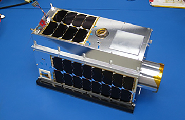
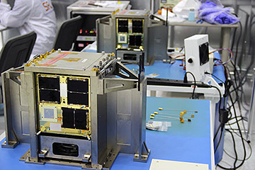
The 2.8kg satellite carries two new technologies that will be tested and validated in space. First is a special low-light camera that can capture and observe in less than two seconds Earth’s horizon glow, a crescent of light occurring on the horizon just before sunrise and after sunset.

Its second new technology is a quad-jet plasma thruster that helps the satellite with altitude control, such as when it enters a lunar orbit.

The SPATIUM-I which stands for Space Precision Atomic-click Timing Utility Mission, was launched from the International Space Station (ISS) in October last year and is currently completing its first phase of experiments.

The 2.6 kg satellite is the first nanosatellite in the world to successfully demonstrate a chip scale atomic clock (CSAC) working in Low Earth Orbit. This demonstrates that the ‘Built-at-NTU’ atomic clock keeps time with a stability of 0.2 billionths in a second, on a par with satellites a thousand times bigger.

Such precision timing devices, which are critical to make on-board electronics function in synchronicity, are usually not found on smaller satellites due to limited space, low power supply and high cost.

The SPATIUM-I is also the first in a planned series of nanosatellites built by NTU that will map out earth’s ionosphere in three-dimension (3D). This will allow NTU scientists to understand the ionospheric morphology and its perturbations that have a pronounced effect on long-distance radio communications, navigation and weather patterns.

NTU Singapore Vice President (Research) Professor Lam Khin Yong said the successful launch and deployment of AOBA VELOX-IV and the SPATIUM-I respectively are important steps forward for NTU.

“Building on NTU Singapore’s satellite engineering expertise over the last decade, our two latest satellite launches demonstrate our leading-edge space capabilities. We have shrunk advanced cameras, thrusters and the electronics capability of larger satellites into something the size of a shoebox,” said Prof Lam.

“Satellite technologies are considered the pinnacle of engineering, given that these machines have to be extremely robust and perform reliably in space, one of the most extreme environments known to mankind. The fact that NTU’s, indeed Singapore’s, first home-made satellite, X-Sat, is still operating after almost eight years, is a testament to the quality and robustness of NTU’s engineered satellites.”

Professor Mengu Cho, Director of Kyutech’s Laboratory of Spacecraft Environment Interaction Engineering, said, “SPATIUM-I and AOBA VELOX-IV are the second and third satellites developed together by Kyutech and NTU. The launches of the two satellites show that the research collaboration between the two universities has grown to multiple aspects.”

“SPATIUM-I is the first in a series of technology demonstrations toward the ionospheric mapping and weather forecasting mission utilising the precise reference signal generated by the chip-scale atomic clock. The mission may bring us tremendous scientific as well as practical and commercial values. AOBA VELOX-IV demonstrates technologies necessary for a future lunar mission, which I really wish to carry out jointly with NTU in the near future.”

“AOBA VELOX-IV was launched as a part of JAXA’s (Japan Aerospace Exploration Agency) Innovative Satellite Technology Demonstration Program. The satellite was chosen by JAXA because of the commercial value of technologies to be demonstrated by AOBA VELOX-IV, which are useful not only for the lunar mission but also for other Earth-orbiting CubeSat missions.” NTU Continues to be at Forefront of Singapore’s Satellite Industry

The AOBA VELOX-IV cube satellite was built by a team led by Mr Lim Wee Seng, Executive Director of NTU’s Satellite Research Centre, while its new altitude determination and control algorithm was developed by Prof Cho’s research team at Kyutech in Japan. It has two solar panels which unfold in space to form a solar array of 30cm x 20cm.

Its primary mission is to capture Earth’s horizon during sunrise and sunset, which would pave the way towards eventually capturing the Lunar Horizon Glow, a phenomenon first observed by Apollo astronauts in the 1960s.

Capturing sharp images requires a superior low-light camera, altitude control algorithm and precise reaction wheels which can rotate and orient the satellite accurately at its target.

Its secondary mission is to test an improved quad-jet pulsed plasma thruster that generates ultra-hot plasma gases by burning solid Teflon fuel. It is used to precisely control the satellite’s angular momentum and rotation, which would be required when orbiting the Moon in any future lunar mission.

SPATIUM-I is the result of innovative engineering by a joint team led by NTU Assistant Prof Holden Li from the NTU School of Mechanical and Aerospace Engineering and Prof Cho from Kyutech.

The team’s miniaturised atomic clock provides an accurate timing reference for the nanosatellite’s on-board electronics and has been successfully tested in space, opening up the possibility of synchronised working with future NTU satellites.

This would allow a group of satellites flying in formation to perform joint missions, for example, the real-time three-dimensional mapping of the ionosphere plasma density, which is the ionized component of the Earth’s upper atmosphere consisting of free electrons that can interfere with electromagnetic waves and radio frequency, and in providing weather forecasting.

SPATIUM-1 will also be testing out several Micro Electro Mechanical Systems (MEMS) technologies, which are miniaturised versions of the various mechanical systems used by larger satellites. One such application of MEMS will be in space-based Internet of Things (Space IoTs).

Currently, land-based Internet of Things (IoTs) are leading the Fourth Industrial Revolution in manufacturing, using sensor data to optimise manufacturing plants, while Smart City applications include monitoring and optimisation of urban traffic and city services.

However, land-based IoTs require infrastructure investment and have a limited range, especially where it does not make economic sense to install wireless transmission devices in smaller, remote towns and villages.

“With the latest NTU-Kyutech timing platform, we may be able to scale up the technology for Space IoTs, which would revolutionise the sensor network in infrastructure-poor regions of the world, to track valuable assets such as vehicles, ships and even livestock,” added Prof Li, principal investigator of the satellite and a scientist at the Temasek Labs @ NTU. “With close to half of the world’s population without access to the Internet, low-cost Space IoTs could be a feasible alternative for providing tracking and monitoring services.”

20 Years of Satellite Expertise

NTU’s first foray into space began 20 years ago. The first project was a communication payload codenamed Merlion, while the main satellite body was developed by the University of Surrey, UK. It was launched in 1999, making this year the 20th year anniversary milestone since NTU begun its space mission.

NTU has since designed, built and sent nine satellites into Earth’s orbit. The X-SAT, NTU’s microsatellite built in collaboration with the DSO National Laboratories, is Singapore’s first locally-built satellite which was launched into space in 2011.

Since 2009, NTU has been running Singapore’s first satellite programme for undergraduates and postgraduates.

From Media Releases 

NanoRacks Racks Up Another International Educational CubeSat Mission on the International Space Station

When CubeSats were first introduced they were a new concept, and now they are a thriving business for NanoRacks which has reached its successful fifteenth CubeSat Deployment mission from the Company’s commercially developed platform on the International Space Station. Recently they released five CubeSats into low-Earth orbit, making it NanoRacks’ one hundred and ninetieth CubeSat released from the Space Station, and the two hundred and twenty eighth small satellite deployed by NanoRacks overall. 

The CubeSats deployed were launched to the Space Station on the sixteenth contracted resupply mission for SpaceX from the Kennedy Space Center in December 2018.

NanoRacks offers an affordable launch opportunity, payload manifesting, full safety reviews with NASA, and managed on-orbit operations that provides an end-to-end solution that met all customer needs.
 
The satellites deployed and their timestamps were:

CAT-1/CAT-2: 10:25 GMT/4:25 CST
Delphini-1: 12:00 GMT/6:00 CST
UNITE: 13:40 GMT/7:40 CST
TechEdSat-8: 16:45 GMT/10:45 CST

UNITE and TechEdSat-8 were both selected for flight by NASA’s CubeSat Launch Initiative (CSLI) and were the two satellites launched for the Educational Launch of Nanosatellites-21 (ELaNa-21) mission complement, sponsored by the NASA Launch Services Program (LSP). 
 

The CubeSat Assessment and Test (CAT-1, CAT-2) investigations are being led by the Johns Hopkins University Applied Physics Laboratory and use two commercial off-the-shelf spacecraft to support a government furnished equipment communications experiment.
 
And lastly, the Delphini-1 CubeSat comes from Aarhus University in Denmark, the University’s first-ever satellite. This proof of concept mission was created under a team effort of the University’s Departments of Physics and Astronomy, Engineering, and Geoscience.
 
“Once again we are demonstrating the diverse CubeSat market that exists today” says External Payloads Manager, Henry Martin. “NanoRacks satellite deployment platforms enable affordable opportunities for everyone from high school, to the university level, to the professional researchers at the Applied Physics Laboratory. The International Space Station is the perfect testbed for those that are new to space and to those that have a long history in orbit, and having such frequent access and opportunity continues to open the door to a growing space marketplace.”


Teledyne Paradise Datacom and Infostellar Create Interoperability Between Stellar Station and QubeFlex LEO Modem.

Infostellar and Teledyne Paradise Datacom (Paradise), part of the Teledyne Defense Electronics Group, have announced the interoperability of Infostellar’s ground station sharing platform, StellarStation, with the groundbreaking QubeFlex™ LEO satellite modem, a flagship product of Paradise.

Infostellar and Paradise aim to provide LEO Satellite operators and ground station owners with a single seamless system able to integrate with existing ground stations by installing StarPass, Infostellar’s sharing device, at the ground station site. This device provides a link between the ground station hardware and StellarStation, which in turn allows Infostellar to rent unused antenna idle time from ground stations and supply it to satellite customers.

This interoperability between the QubeFlex™ modem and StellarStation bridges an “access gap” in the current market.  It enables a much larger swath of smaller end users globally to affordably access CubeSat data, without a capital investment in earth station equipment, while also giving ground station operators the opportunity to sell unused capacity.

Executive Comments

Andrew Young, Head of Ground Systems Engineering at Infostellar, said the QubeFlex Satellite Modem is the first off-the-shelf satellite modem the company has seen that was designed specifically for CubeSat and smallsat users. This, along with its track record of interoperability with a variety of CubeSat transmitters, is the reason Infostellar has added support for this product to the firm’s StarPass device.

Paul McConnell, Business Development Director for Paradise, noted that interoperability between space assets and ground segment has always been important to users. StellarStation takes the concept of interoperability a step further and together with Q-Flex provides a seamless, quick and flexible ground solution for new space.

On the SmallSat Symposium Show Floor: KenCast to Demo Their Fazzt Platform

At the SmallSat Symposium 2019, February 4-7, in Mountain View, California, KenCast will demonstrate the latest KenCast Fazzt platform the company is bringing to market to enable secure, hi-reliable, cost-effective content delivery on the pending future satellite networks to fixed sites and vehicles-on-the-move.

The current dramatic changes — in satellite (HTS GEO, MEO, and LEO constellations) and terrestrial networking and cloud storage —- bring new operational capabilities and content delivery application opportunities on a global scale that have never been available before.  KenCast has continually enhanced their Fazzt content delivery platform over the last 25 year by extensive work for, and with feedback from, our major military, public safety, cinema industry, commercial, financial institution, lodging, and digital signage customers.

KenCast’s customers include:

  • DISA (Defense Information Systems Agency)
  • Hollywood/DCDC
  • The New York City Fire Department
  • NOAA (National Oceanic Atmospheric Administration)
  • and others…

For these delivery applications, KenCast offers a wide range of products and services:

  • Optimal deployment and operation of these new satellite networks,
  • Customizing solutions to each customer’s requirements
  • Planned enhanced capabilities — remotely deployed periodically and repeatedly updated
  • Support for new hybrid networking opportunities, as these options arise, from constantly improving:
  • GEO
  • NGOS (MEO, LEO, Nanosatellite)
  • CDNs
  • Fiber, Laser 
  • Antennas

KenCast’s engineering expertise and services include:

  • Network Design and Optimization,
  • Cyber-Security plan, implementation, and service,
  • Staff training,
  • Remote IT monitoring and support services.


Myriota’s IoT Product Uses Low Cost Earth-To-Satellite Comms Technology

Satellite communications company Myriota has announced the first of a string of commercial products that will use their low-cost Earth-to-satellite transmission technology.

The South Australian company has partnered with fellow Australian business Davey Water Products to add its Internet of Things (IoT) connectivity to Davey’s TankSense product range, enabling farmers to receive water level data direct to their mobile phones. The product is expected to be commercially available in the second half of the year and will be the first mass-market water-level sensor to be connected via Myriota’s low-cost earth-to-satellite transmission technology. It will help farmers manage water usage and monitor livestock water supply in areas where cellular networks are unreliable or unavailable.

Myriota CEO Dr. Alex Grant said the product would benefit farmers who had faced exorbitant costs for satellite connectivity in the past or struggled to reliably monitor their water systems via existing technology. “Our technology removes the need for farmers to rely on cellular networks with patchy coverage, or spend large sums of money to connect to high-cost satellites,” hetsaid. “We’re excited that this partnership will lower the cost of water management in locations that up until now have had no cost effective way of retrieving data.”

Myriota launched their next generation of technology on Spaceflight’s SmallSat Express mission aboard a SpaceX Falcon 9 late last year.

Myriota Business Development Executive Tom Rayner said the Davey Water Products sensor was the first of a number of new product announcements the company expected to make in the coming weeks. He said while agriculture was an important industry for Myriota, the company was also working on products for utilities metering, environmental monitoring, defence and in the asset tracking and logistics space.

We’re working with dozens of companies across a whole range of industry verticals and there are quite a few products in development,” Rayner said. “This is the first one we’ve announced and given the profile of Davey it’s one that we’re quite pleased about.”

Myriota has been scaling up since the company was spun out of the University of South Australia in 2015 and last year raised $15 million through a Series A funding round, with Boeing HorizonX Ventures among the contributors.

Rayner said 2019 would be the year the company’s products hit the mass consumer market. He said demand for the Davey product would be strong among farmers in Australia’s vast Outback and globally. “It’s a huge issue for people in Australian agriculture that they don’t have access to reliable, low-cost communications infrastructure, particularly for these IOT applications where the cost has to be ultra-low to make them work so we see a lot of demand here,” Rayner said. “But anywhere that you can’t justify the installation of a terrestrial-based tower this technology has got a place so we’ve already had strong demand for this product in North and South America, Asia and New Zealand — it really is global.”

Davey’s sensors are bolstered by their inbuilt AI capability, which rely on algorithms to increase the accuracy of predictions around when a tank will run out of water.

Davey Water Products General Manager Innovation Joel Gresham said the combination of the TankSense product with Myriota’s technology would provide a world first in terms of communicating with remote locations. “We launched the first AI driven monitoring and control app for tank water management last year and now, we’re embarking on another world first,” Gresham said. “Thanks to Myriota’s low cost satellite technology, farmers who have traditionally needed to manually check their tanks will now be able to monitor their assets seamlessly from any location.”

South Australia has been a major player in the nation’s space industry and is home to major Tier 1 defence companies and several emerging space start-ups. In December, the state’s capital Adelaide was announced as the home of Australia’s new space agency. Meanwhile, another Adelaide-based IOT space company Fleet yesterday announced in Amsterdam their plan to connect 1 million LoRaWAN devices around the globe for $2 per device per year.

Myriota uses exactEarth’s LEO satellite constellation for their connectivity solutions.

Story is authored by Andrew Spence of The Lead.

Kratos Successfully Commands Spacecraft Using the U.S.A.F.’s Enterprise Ground Services Framework

Kratos Defense & Security Solutions, Inc. (Nasdaq: KTOS) has commanded an on-orbit spacecraft using the U.S. Air Force’s Enterprise Ground Services (EGS) framework.


The CCS-C provided consolidated MILSATCOM tracking, telemetry and command capability for 14th Air Force / 50th Space Wing launch and early orbit, on-orbit and anomaly resolution operations.
Photo is courtesy of the U.S.A.F.

This demonstration directly follows on the heels of three successful pathfinder studies announced earlier by Kratos for migrating the Command and Control System – Consolidated (CCS-C) ground system to the EGS architecture. CCS-C provides consolidated MILSATCOM tracking, telemetry and command capability for 14th Air Force and the 50th Space Wing.

The Kratos demonstration supports the U.S. Air Force’s strategic approach to implementing a common, service-based satellite ground infrastructure that will evolve current satellite ground systems into a single platform.  EGS is a critical enabling technology that is focused on a sustainable, resilient space architecture that can respond to emerging threats and protect space-based assets.

Kratos EGS software and services commanded an on-orbit spacecraft and demonstrated multiple capabilities supporting the EGS framework. These included the EGS service paradigm and dynamically allocating satellite ground resources and executing deployment automation with the ability to spin up new satellite command and control instances in less than 10 minutes.

Technology Readiness Level (TRL) is a method of estimating technology maturity of critical technology elements of a program during the acquisition process. Evidence of TRL 8 was proven in the following ways:

  • Kratos Commercial Off-The-Shelf (COTS) software natively mapped into the EGS service paradigm.
  • The deployment automation solution was shown to work on two different vendor technology stacks.
  • Kratos EGS integration software completely decoupled each EGS service from all other services using the NASA Goddard GMSEC message bus.  
  • Kratos COTS software was utilized to demonstrate the implementation of EGS services including Telemetry and Command Processing, Automation, User Experience, Orchestration and a Range Interface.

TRL 8 readiness means that the actual system was completed and mission qualified through test and demonstration in an operational environment. 


Artistic rendition of the Altair Pathfinder satellite. Image is courtesy of Millennium Space Systems.

The entire test and demonstration was accomplished working cooperatively with Millennium Space Systems, a Boeing company, and their on-orbit Pathfinder spacecraft, Swedish Space Corporation with their worldwide ground antenna network and the U.S. Air Force’s Space Management Battle Lab (SMBL) in Colorado Springs, Colorado.

Executive Comment

Larry Lind, VP of Kratos Federal Program, said these capabilities are critical to achieving a resilient EGS and the agility needed to survive the new realities of space. In the past, the demonstration of a new satellite ground command and control station has taken months and, in many cases, years to execute. The test and demonstration of this first live contact run out of the Space Mission Battle Lab was made possible in less than three weeks and its success validated TRL 8 readiness of Kratos EGS technology.