Successful Space Debris Demo Performed On-Orbit by Tethers Unlimited

Tethers Unlimited, Inc. (TUI) has successfully demonstrated on-orbit operation of the Terminator Tape, an affordable, lightweight solution for removing space debris from on-orbit.

In early September of 2019, an automated timer unit on the Prox-1 satellite, launched in late June 2019 by the U.S. Air Force Research Laboratory’s University Nanosatellite Program, activated deployment of TUI’s Terminator Tape module. The Terminator Tape is a small module, weighing less than two pounds and about the size of a notebook, designed to attach to the exterior of a satellite.


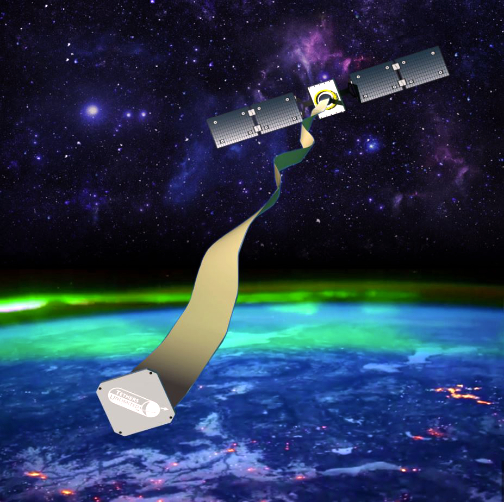
The Terminator Tape Deorbit Module interacts with the space environment to rapidly drag a satellite out of orbit.

Image is courtesy of Tethers Unlimited.

When the satellite has completed its mission and is ready to be disposed of, an electrical signal from either the satellite or an independent timer unit will activate the Terminator Tape, causing it to deploy a 230-foot long conductive tape from the satellite. This tape interacts with the space environment to create a drag force on the satellite that lowers its orbit far more rapidly than it would if it were simply abandoned in orbit.

TUI is currently collaborating  with Millennium Space Systems, TriSept, and RocketLab to prepare a scientific method-based LEO flight experiment called “DRAGRACER” which will compare the de-orbit of two identical satellites, one with and one without a Terminator Tape, in order to enable robust characterization of the tape’s performance.

Dr. Rob Hoyt, TUI’s CEO, said that three months after launch, as planned, the company’s timer unit commanded the Terminator Tape to deploy and from observations by the U.S. Space Surveillance Network that the satellite immediately began de-orbiting over 24x faster, instead of remaining on-orbit for hundreds of years. Rapidly removing dead satellites in this manner will help to combat the growing space debris problem. This successful test proves that this lightweight and low-cost technology is an effective means for satellite programs to meet orbital debris mitigation requirements.


New SAR Smallsat Platform Debuts from Capella Space

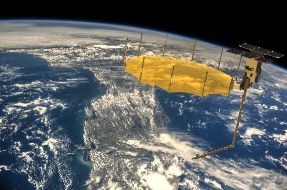
Capella Space has unveiled their evolved satellite design to enable on-demand observations of any location on Earth.


Capella Space SAR smallsat to Deliver high resolution, on-demand EO data.

Artistic rendition is courtesy of the company.

Informed by extensive customer feedback and findings from the launch of Denali, Capella’s testbed satellite, the re-engineered design features a suite of technological innovations to deliver timely, flexible and frequent sub-0.5 meter very high quality images to the market. According to the company, the enhanced technology package will deliver the most advanced offering for small satellite SAR imagery on the market. The satellite evolution is a direct result of customer feedback, extensive on-orbit testing with Capella’s first testbed satellite Denali, as well as ground-based testing.

Satellite enhancements include:

  • Advanced design delivering high contrast, low-noise, sub-0.5 meter imagery: A 3.5 meter deployed mesh-based reflector antenna combined with a high power RADAR enable key performance improvements including quality advances.
     
  • Extended duty cycle: A deployed 400 W solar array increases on-orbit duty cycle to 10 minutes per orbit.
     
  • Continuous imaging over long distance: Advanced thermal management systems allow continuous imaging of up to 4000 km long strip images.
     
  • Highly agile platform: Enabled by large reaction wheels, the new satellite quickly adjusts pointing to collect images from diverse targets.
     
  • Staring spotlight image mode: New mode further enhances image quality with the ability to collect the highest commercially available multi-look data.
     
  • Enhanced data downlink rate: A high average data rate downlink of 1.2 Gbps supports the massive image collection rate and extended duty cycle, providing more data per orbit than any other commercial SAR system in its class.
     
  • Real-time tasking: A highly secure encrypted two-way link with Inmarsat through an exclusive partnership with Addvalue provides real time tasking capability for the entire Capella constellation.


The new satellite design cemented major deals with multiple divisions of the U.S. government, including a contract with the U.S. Air Force and National Reconnaissance Office (NRO). The technological enhancements will be embedded in Capella’s next six commercial satellites, named the “Whitney” constellation, starting with the launch of Sequoia slated for March of 2020. The Sequoia satellite is currently completing system level tests and will arrive at the launch site in early March.

Capella is also licensed by the National Oceanic and Atmospheric Administration (NOAA) for its 36 small satellite constellation, along with approval to sell the highest resolution legally allowed SAR commercial imagery to customers globally.

Christian Lenz, VP of Engineering at Capella Space, said the firm’s customers have spoken: today’s industry standard of waiting eight hours to receive data is woefully outdated. They want access to imagery that is reliable, timely and, most importantly, high-quality. The innovations packed into Capella’s small satellite make Capella the first and only SAR provider to provide real-time tasking and capture of sub-0.5 meter, very high-quality imagery anywhere on Earth at any time. This is a game-changer for a variety of industries—from monitoring military threats to assessing crop yields in agriculture to coordinating disaster response.

U.S. Space Development Agency Soliciting Pitches for Surveillance Satellite Constellation Builds

The Space Development Agency (SDA) is responsible for defining and monitoring the Department’s future threat-driven space architecture and accelerating the development and fielding of new military space capabilities necessary to ensure U.S. technological and military advantage in space for national defense. The SDA is now soliciting proposals for the technologies that are necessary to build and launch multiple smallsats (from 50 to 500 kg.) that will form the national defense constellations.

The SDA is responsible for unifying and integrating next-generation space capabilities to deliver the National Defense Space Architecture (NDSA), a resilient, military sensing and data transport capability via a proliferated space architecture in LEO. SDA will not necessarily develop and field all capabilities of the NDSA but rather orchestrate those efforts across the Department of Defense (DoD) and fill in gaps in capabilities while providing the integrated architecture.

There are eight essential capabilities described in the SDA’s August 2018 Report on Organizational and Management Structure for the National Security Space Components of the Department of Defense. These capabilities include:

1. Persistent global surveillance for advanced missile targeting,

2. Indications, warning, targeting, and tracking for defense against advanced missile threats,

3. Alternate positioning, navigation, and timing (PNT) for a GPS-denied environment,

4. Global and near-real time space situational awareness,

5. Development of deterrent capability,

6. Responsive, resilient, common ground-based space support infrastructure (e.g., ground stations and launch capability),

7. Cross-domain, networked, node-independent battle management command, control, and communications (BMC3), including nuclear command, control, and communications (NC3),

8. Highly-scaled, low-latency, persistent, artificial-intelligence-enabled global surveillance.

Initially, the National Defense Space Architecture is comprised of the following layers to address the critical priorities for space identified within the DoD Space Vision:

  • Transport Layer, to provide assured, resilient, low-latency military data and communications connectivity worldwide to the full range of warfighter platforms
     
  • Battle Management Layer, to provide architecture tasking, mission command and control, and data dissemination to support time-sensitive kill chain closure at campaign scales
     
  • Tracking Layer, to provide global indications, warning, tracking, and targeting of advanced missile threats, including hypersonic missile systems
     
  • Custody Layer, to provide 24×7, all-weather custody of time-sensitive, left-of-launch surface mobile targets (e.g., to support targeting for advanced missiles)
     
  • Navigation Layer, to provide alternate positioning, navigation, and timing (PNT) for Global Positioning System (GPS)-denied environments
     
  • Deterrence Layer, to deter hostile action in deep space (beyond Geosynchronous Earth Orbit (GEO) up to lunar distances)
     
  • Support Layer, to enable ground and launch segments to support a responsive space architecture


Multiple awards are anticipated. The amount of resources made available under this BAA  will depend on the quality of the proposals received and the availability of funds.

SDA’s mission starts and ends with the warfighter. SDA recognizes that “good enough” capabilities in the hands of warfighter sooner may be better than delivering the perfect solution too late. SDA will deliver capabilities to the nation’s joint warfighting forces in two-year tranches, starting as early as Fiscal Year (FY) 2022.

SDA anticipates issuing separate solicitations for the capability layers outlined above, seeking systems and technologies that can be developed and fielded on the SDA tranche timelines to address timely warfighter needs. SDA also recognizes the need to establish an “intellectual pipeline” to access ideas from across the community to inform the future of the NDSA.

Through this BAA, SDA specifically seeks novel architecture concepts, systems, technologies, and capabilities that:

  • Enable leap-ahead improvements for future tranches of currently planned NDSA capability layers
     
  • Enable new capability layers to address other emerging or evolving warfighters needs

To this end, SDA is soliciting executive summaries, white papers/proposal abstracts as well as full proposals.

Please access this direct link to download a 32-page PDF that contains the details, focus areas and submission instructions.

The First All-Iodine Electric Propulsion Systems Launched by Busek Company

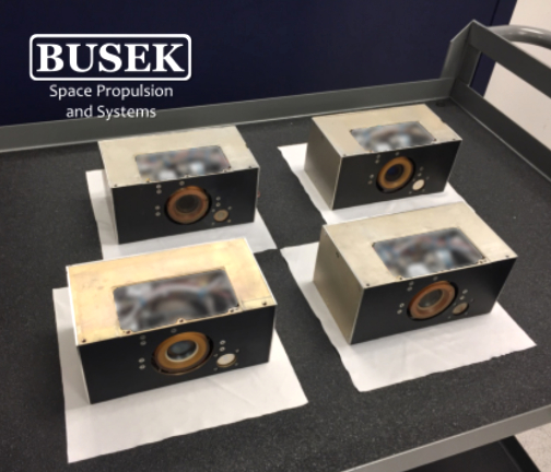
Space propulsion firm Busek Co. Inc. confirmed the first two deliveries of the firm’s BIT-3 ion thruster, an all-iodine solar electric propulsion system.

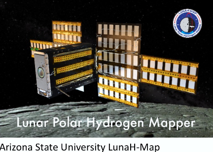
The compact, low power thruster system is a key enabling technology for a number of upcoming smallsat missions, including Lunar IceCube program, lead by Kentucky’s Morehead State University, and LunaH-Map, lead by Arizona State University.

Both missions are manifest as a ride-shares on NASA’s SLS Artemis-1 and they rely on the Busek thruster to inject the satellite into a lunar capture orbit.


After successful capture, the BIT-3 thruster will provide controlled descent to a science-mission altitude of roughly 100 km. (62 mi.), where the teams’ science instruments will survey the Moon for water ice. Accurate mapping of Lunar ice deposits is a critical first step for long-term human lunar missions and cis-lunar infrastructure development.

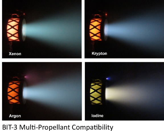
The BIT-3 iodine thruster system is capable of generating up to two kilometers per second (4,474 m.p.h.) of delta-v for cubesats, opening the possibility for small spacecraft to complete a range of missions previously reserved for large, high-cost satellites. BIT-3 is a true turn-key system and includes highly integrated control electronics, iodine storage and feed system, thruster, neutralizer, and optional gimbal for attitude control.

The BIT-3’s Chief Scientist and Program Manager, Dr. Mike Tsay said, the key to the system’s compact size, efficiency, and performance density are its use of solid iodine propellant. Iodine eliminates the need for bulky pressurized gas storage and feed components. The company hurdled significant obstacles to adapt the use of iodine in ion engines and the lessons the firm has learned are informing a range of activities here at Busek.


Artistic rendition of Morehead State University’s LunarIceCube small.sat.

Professor Ben Malphrus, Principal Investigator of Morehead State University’s Lunar IceCube mission, added the BIT-3 represents a technology that will enable future exploration of the solar system with small satellite platforms.  Low thrust propulsion systems such as the BIT-3, combined with low energy manifold trajectories that make up the interplanetary superhighway, have the potential to usher in a new era of planetary exploration.

Dr. Craig Hardgrove, Principal Investigator for the LunaH-Map mission, said iodine electric propulsion has unique potential among safe propellant choices for small exploration missions. The BIT-3’s size and performance plays a critical role in Arizona State’s mission to the moon.

Smallsat Launch Services Agreement Signed Between Firefly Aerospace and ISILAUNCH

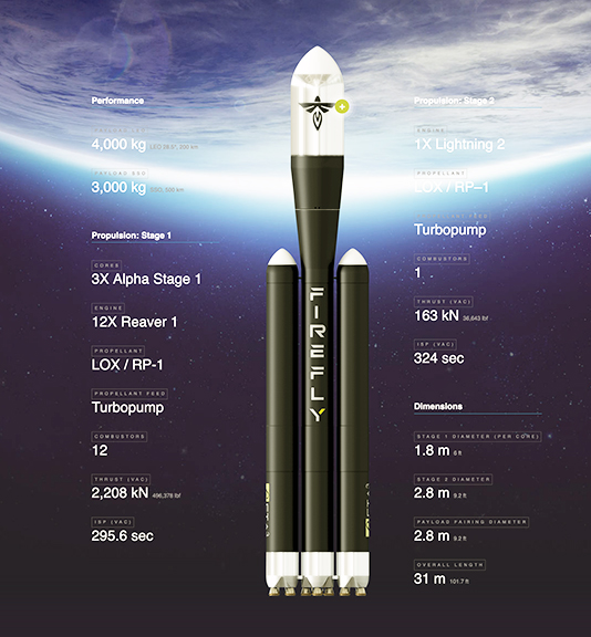
Firefly Aerospace, Inc. (Firefly) has executed a Launch Services Agreement with Innovative Space Logistics BV (ISILAUNCH), a launch services subsidiary of Netherlands based ISIS – Innovative Solutions in Space B.V. (ISISPACE).

Under the agreement, ISILAUNCH will offer to its customers multiple dedicated and rideshare launch opportunities on the Firefly’s Alpha launch vehicle, on missions beginning in 2020.

Firefly CEO Dr. Tom Markusic stated the company is very pleased to have ISILAUNCH as a customer for the firm’s Alpha launch vehicle.

He noted that with Firefly’s anticipated flight rate and the growth of the demand for launch services, the company will leverage the experience and market presence of ISILAUNCH to provide customers with economical, convenient and reliable flight opportunities.

ISILAUNCH Director Abe Bonnema said the firm is very keen to work with Firefly and their Alpha launch vehicle. Based on the company’s extensive experience with cluster launches, having launched hundreds of small satellites in that manner over the past ten years, ISILAUNCH believes the Alpha launch vehicle has a very interesting capacity to cost ratio, enabling the launch configuration flexibility the company needs to serve a broad customer base.


ISIS specializes in realizing innovative turn-key small satellite missions. Through our unique and proven approach of full vertical integration which combines design, development, production, testing, launch services, and satellite operations into a single organization, we can offer you the right solution, from subsystem to full mission and constellation building.

He added that Alpha is also interesting for the firm’s ambitions to bring swarms of small satellites to lunar orbit. Moreover, the company is pleased to conclude that the firm’s business philosophy and market approach align very well with those of Firefly.

Alona Kolisnyk, Firefly Director of International Business Development, added that the company’s team is preparing to quickly ramp flight cadence following the maiden launch of the firm’s Alpha vehicle. This will allow Firefly to deliver customer payloads to their preferred orbits in a responsive and affordable way. The rideshare missions Firefly will execute with ISILAUNCH will further enable the global small satellite industry and provide flight heritage to disruptive cislunar technologies being developed by commercial space startups.

Strategic Partnership Formed Between HawkEye 360 and Airbus

HawkEye 360 Inc. has formed a strategic partnership with Airbus and, through this partnership, the companies will deliver high-impact, geospatial intelligence solutions not currently available — both companies can leverage the platforms and services of the other partner to address client mission needs.

This partnership enables HawkEye 360 and Airbus to fuse complementary data sets to maximize value to customers. Airbus will distribute HawkEye 360’s RF data and analytics across Europe to augment its maritime, defense, and intelligence products. HawkEye 360 will offer Airbus’ earth observation optical and synthetic aperture radar (SAR) products jointly with its RF solutions to serve defense and intelligence customers.


Artistic rendition of HawkEye 360’s constellation is
courtesy of the company.

Airbus was among the investors who participated in HawkEye 360’s $70 million Series B funding in August 2019. The Committee on Foreign Investment in the United States (CFIUS) provided approval for Airbus to close its investment transaction Jan. 8. The Series B funding enables HawkEye 360 to build and launch the full commercial satellite constellation and develop a full line of RF analytic products.

John Serafini, CEO, HawkEye 360, said Airbus is an exceptional partner and investor as the company develops and delivers the firm’s vision for the future of space-based RF data and analytics. Together with Airbus, HawkEye 360 will be able to build sophisticated products and services that intelligently leverage a more comprehensive range of data than previously commercially available.

François Lombard, Director of the Intelligence Business for Airbus Defence and Space, noted that HawkEye 360 is a pioneer in space-based RF data and analytics and an ideal partner in the company’s  mission to improve global situational awareness for our defense, security, and civil customers.

Alex Fox, EVP of Business Development, Sales and Marketing, HawkEye 360, added that the world’s first EO, SAR, and RF commercial constellation offers unique capabilities, such as a tip-and-cueing Multi-INT system for unprecedented global situational awareness. Integrating these analytics will provide customers valuable insights to execute more informed decisions.

Egypt is Set to Launch a Program for the Manufacturing of Small Satellites in Universities

Egypt is set to launch a program for the manufacturing of small satellites in universities across the country in a collaborative effort led the Egyptian Space Agency (EgSA), the Academy for Scientific Research and Technology (ASR) and the Supreme Council of Universities. 


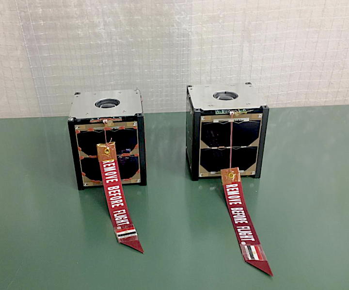
Egypt’s indigenously developed Cubesats NARSSCube 1 & 2 Flight Models. Photo Credit: NARSS

The program is one of the pillars contained in the National Strategy for Science, Technology and Innovation 2030 which was released in December by Egypt’s Higher Education and Scientific Research aimed at improving the country’s competitiveness in science research and development of indigenous technologies. 

The strategy document, obtained by Space in Africa, outlined the Ministry’s intention to “establish a laboratory for educational satellites, electronic tests and space photographs processing.”

Egypt’s Higher Education and Scientific Research Minister Khaled Abdel-Ghafar yesterday confirmed plans for the launch of the program while chairing the maiden meeting of the Egyptian Space Agency board alongside Mohamed El-Qosi, EgSA Chief Executive Officer.

Abdel-Ghafar further disclosed that the ministry will welcome a delegation from the French Space Agency to discuss space cooperation between both countries. Both parties will be looking to sign a memorandum of understanding on space cooperation.

The program for the manufacturing of small satellites in universities across Egypt is a reflection of the country’s recent drive to revitalize its space sector and its ambition to become a space power in the Middle East and Africa. 

Last year, Egypt launched four satellites into space, of which two were developed locally by Egyptian engineers at the National Authority for Remote Sensing and Space Sciences (now the Egyptian Space Agency). With a record nine satellites launched into space from 1998 to 2019 by Egypt’s Nilesat and the Egyptian government, Egypt currently tops the chart for the highest number of satellites launched by an African nation.

The North African country is also investing in other space infrastructure including a satellite assembly, integration and testing (AIT) centre, ground station facilities and the China-funded MisrSat II Earth observation satellite in collaboration with the Chinese government. Located in the iconic Egyptian Space City near the New Administrative Capital in Cairo, the space facilities, when completed, will boost Egypt’s competitiveness in space science research and technology development.

By Joseph Ibeh,  AfricaNewsSpace

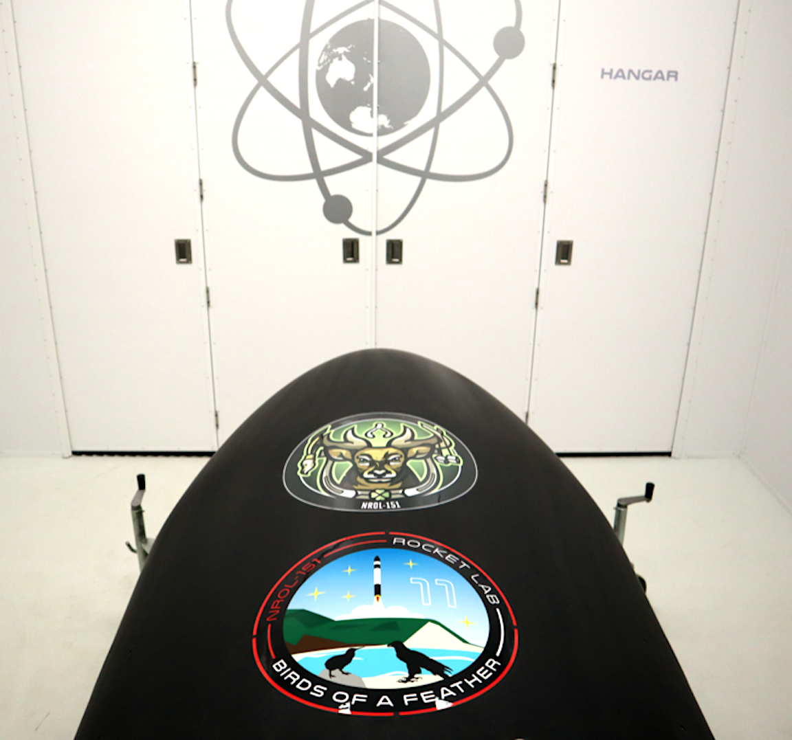
Rocket Lab Gets their Ducks in a Row for National Reconnaissance Office’s ‘Birds of a Feather’ Mission 

Rocket Lab has been selected by the U.S.’  National Reconnaissance Office (NRO) to assist with their mission, ‘Birds of a Feather’, sending a small satellite off from Rocket Lab Launch Complex 1. The window of the launch begins to open on January 31, NZDT (New Zealand).  Rocket Lab has facilities in both the U.S. and New Zealand.

The NRO competitively awarded the contract under the Rapid Acquisition of a Small Rocket (RASR) contract vehicle. RASR allows the NRO to explore new launch opportunities that can provide a streamlined, commercial approach for getting small satellites into space. 

Rocket Lab’s Senior Vice President – Global Launch Services, Lars Hoffman, commented that the Electron vehicle is uniquely placed to deliver the kind of frequent, rapidly-acquired launch opportunities required by the NRO and other government agencies to ensure resiliency in space. 

Rocket Lab has been launching to orbit since January 2018, and remains the only launch provider capable of meeting the rapid-acquisition and launch requirements of dedicated small satellite missions for the U.S. government. Rocket Lab has delivered 47 satellites to orbit on the Electron launch vehicle, enabling operations in space debris mitigation, Earth observation, ship and airplane tracking, and radio communications

Hoffman continued that they are honored the NRO has selected Rocket Lab as the launch provider for this dedicated mission. The Electron launch vehicle is perfectly positioned to provide the kind of rapid and responsive access to space that puts the NRO in complete control over their own launch schedule and orbital requirements. As the industry shifts toward the disaggregation of large, geostationary spacecraft, Electron enables unprecedented access to space to support a resilient layer of government small satellite infrastructure. 


Kleos Space Geollect as a Channel Partner and Data Integrator

Kleos Space S.A. (ASX:KSS, Frankfurt:KS1) has entered into a channel partner and data integrator agreement with UK geospatial intelligence and analysis company Geollect.

Geollect will procure and integrate data from Kleos’ satellites as it becomes a global leader in dark vessel tracking capability whereas Kleos data will be used by Geollect to generate analytical intelligence output and may be resold to third parties. The agreement is the result of Kleos’ and Kleos’ UK subsidiary efforts to assist the UK Industry and Government to access commercial data from satellites to provide information as needed.


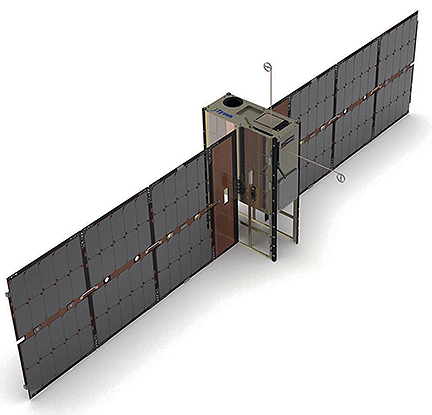
Artistic rendition of a Kleos Space smallsat on-orbit.

Kleos’ Scouting Mission satellites detect and geolocate maritime radio frequency transmissions, and when compared with other data sources such as Automatic Identification System (AIS) the data can be used to highlight ‘dark’ maritime activity. Geollect provides near real-time geospatial maritime intelligence collection and analytics for the defence, security, global cruise line and insurance sectors that is used by leading maritime organisations. Comprehensive real-time vessel tracking is central to its extensive contracts with the UK’s Royal Navy and within the Global P&I Maritime insurance sector, using its intelligence capabilities to support global maritime operations.
This agreement with an international leader in geospatial intelligence supports Kleos’ long-term strategy within the UK defence and security markets, where its commercial satellites improve and verify intelligence, surveillance and reconnaissance (ISR) data to support maritime operations.

Kleos’ Scouting Mission satellites are awaiting launch from Chennai, India, and after commissioning will commence data delivery.

Kleos Space Chairman, Air Commodore (retired) Peter Round said that this is a great example of implementation of a key business strategy for Kleos. The company can provide defence, security and commercial users with access to cost-effective geolocation intelligence data to provide a value added tipping and cueing capability to their current capability. Kleos’ independent maritime intelligence data complements and enhances Geollect’s existing datasets. Using the firm’s satellites flown in clusters of four, Kleos technology geolocates all RF transmissions without relying on them actively broadcasting their locations. Thus, Kleos can offer unprecedented situational awareness at sea with optimized revisit rates over key regions of maritime interest for the UK, including the Straits of Hormuz, the South China Sea and the coast of Africa.

Geollect co-founder and COO Richard Gwilliam added that the company’s maritime defence and security customers, such as the Royal Navy, are increasingly requesting tracking of dark activity, facilitating improved detection and interdiction of illegal activity such as piracy and drug smuggling. Kleos’ data will improve our location of dark vessels, enabling us to identify anomalous activity and corroborate reports from disparate sources in near real- time. The geospatial intelligence data and analysis allows customers to understand regional threats as they occur and use that information to mitigate risks.”


Smart Smallsat Pony Express 1 Developed by Lockheed Martin Now On-Orbit and Performing Well

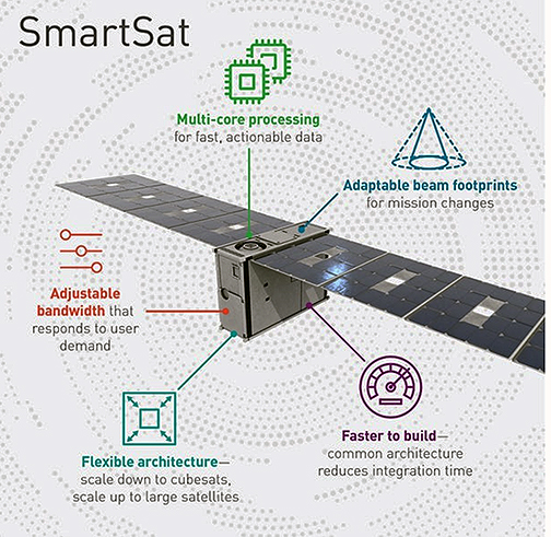
A new era of space-based computing is now being tested on-orbit that will enable artificial intelligence (AI), data analytics, cloud networking and advanced satellite communications (SATCOM) in a new software-defined architecture.


Artistic rendition of Tyvak’s 6U smallsat platform.

Image is courtesy of the company.

Recently, Lockheed Martin (NYSE: LMT) launched the Pony Express 1 mission as a hosted payload on Tyvak-0129, a next-generation Tyvak 6U smallsat.

Pony Express 1, an example of rapid prototyping, was developed, built and integrated in nine months, and was funded completely by Lockheed Martin Research and Development funding. This orbital proving ground is validating payload hardware and software, and is packed with new technology that fits into a satellite the size of a shoebox. Some of the key technologies being flight-tested include:

  • HiveStar™ software validates advanced adaptive mesh communications between satellites, shared processing capabilities and can take advantage of sensors aboard other smart satellites to customize missions in new ways previously difficult to achieve in space.
     
  • A software-defined radio that allows for high-bandwidth hosting of multiple RF applications, store-and-forward RF collection, data compression, digital signal processing and waveform transmission.
     
  • 3D-printed wideband antenna housing developed by Lockheed Martin’s Advanced Research Technology Center.


Pony Express 1 is a dual-use payload that enables mesh networks in space through HiveStar™ and a second function that tests space to ground remote sensing. Future research missions this year, like Pony Express 2, will further advance cloud networking concepts among satellites, as well as validating Lockheed Martin’s SmartSat™ software-defined satellite architecture which enables streamlined hosting of flexible mission apps.

This mission consists of two, 12U cubesats with faster, more capable ultra-scale processors that unlock in-orbit data analytics and artificial intelligence. Equipped with miniaturized cross-link and precision timing, Pony Express 2 is a trailblazer for autonomous teaming in space and true cloud networking.

Rick Ambrose, EVP of Lockheed Martin Space, said that early on-orbit data shows Pony Express 1 is performing its important pathfinding mission very well. Lockheed Martin’s HiveStar™ technology on board will give the firm’s customers unparalleled speed, resiliency and flexibility for their changing mission needs by unlocking even greater processing power in space. This is the first of several rapid, self-funded experiments demonstrating our ability to systematically accelerate our customers’ speed to mission while reducing risk from new technologies.