Horizon Technologies Presents @ Airborne ISR Conference Regarding SIGINT Platforms Merging With Space-Driven Amber Smallsat Constellation

Horizon Technologies CEO, John Beckner, spoke at the Airborne ISR Conference in London on  October 23-24, 2019.

Beckner gave a presentation on trends in Sat Phone SIGINT for ISR and emphasized how airborne and ground-based strategic SIGINT platforms and their output will be merged with the upcoming availability of space-driven Amber data next year.

Amber is the public/private partnership with the UK Government to launch a cubesat constellation to provide a Maritime Intelligence data product for its government users.

At the Conference, Beckner announced that Horizon Technologies had recently been awarded a “plus-up” to a current NATO-user FlyingFish™ contract worth over £2.4 million through 2024.

The 5th Annual Airborne ISR conference in London covered Maritime Patrol, Data Dissemination, UAV Technology, International Surveillance Cooperation, AWACS, 5th Generation ISR, Industrial Engagement, and Threat Evolution in detail. During the UAV ISR sessions, Horizon Technologies discussed the upcoming deployment of UAVs being tasked on FRONTEX missions to include Horizon Technologies miniature Xtender SIGINT technology.

Beckner also presented at the Global Maritime Forum Annual Summit in Singapore. Asia is a key market for both FlyingFish™ and the Amber maritime intelligence data service. Beckner and the Horizon Technologies team met with customers and decision makers from all over the world at the Summit which convened leaders from across the maritime spectrum who need to address the burning issues facing the maritime industry.

Working together and building on the outcomes of the Global Maritime Forum’s Annual Summit in Hong Kong, they are developing solutions for a safe, clean, inclusive and efficient maritime industry – goals that can unleash the potential of global seaborne trade and increase sustainable long-term economic development and human well-being. Horizon Technologies Amber data, and the governments who use it, will have a major positive impact on meeting these goals.

Forrester Reports: Another Billion Being Sought by OneWeb


Journalist
Chris Forrester.

According to journalist Chris Forrester, filing at the Advanced Television infosite, satellite mega-constellation OneWeb is seeking to raise another $1 billion (€0.9bn) as it starts work on orbiting 30 satellites per month in a few weeks. OneWeb wants to circle the planet with an initial batch of 650 satellites for broadband services.

OneWeb is backed, in part, by Japanese media conglomerate SoftBank, although there are also reports that SoftBank is looking to exit the business.

The report, from the UK’s Sunday Telegraph, stated that OneWeb’s ‘cash call’ will come ahead of SoftBank’s results statement due on November 6th. However, SoftBank has already written down about £380 million of their OneWeb investment. However, the newspaper reports that SoftBank remains committed to OneWeb.

China Launches Three Chinese Satellites Plus a Sudanese SRSS-1 Smallsat 

On Sunday November 3, China launched a new Earth Observation (EO) satellite, Gaofen-7, which will play an important role in land surveying and mapping, urban and rural construction and statistical investigation, according to the China National Space Administration (CNSA).

The Gaofen-7, launched on a Long March-4B rocket at 11:22 a.m. (Beijing Time) from the Taiyuan Satellite Launch Center in north China’s Shanxi Province, is China’s first, civil-use, optical transmission, three-dimensional surveying and mapping satellite that reaches the sub-meter level, CNSA said.


Artistic rendition of the Gaofen-7 satellite which, along with the carrier rocket, were developed by the China Academy of Space Technology and the Shanghai Academy of Spaceflight Technology under the China Aerospace Science and Technology Corporation.

The satellite and carrier rocket were developed by the China Academy of Space Technology and the Shanghai Academy of Spaceflight Technology under the China Aerospace Science and Technology Corporation. The users of the Gaofen-7 satellite will be mainly from the Ministry of Natural Resources, the Ministry of Housing and Urban-Rural Development and the National Bureau of Statistics.

Via the same carrier rocket, three other commercial and scientific experiment satellites including one developed for Sudan were also sent into space.

The satellites onboard include Gaofen 7, Xiaoxiang-1 08, Whampoa 1, all belonging to China, plus a remote sensing satellite owned by Sudan. The Sudan Remote Sensing Satellite, SRSS-1, was developed for the Sudanese government by the Shenzhen Aerospace Oriental Red Sea Satellite Co.


A Chinese Long March 4B rocket lifts off. Image is courtesy of Xinhua.

The Sudanese smallsat was designed for both civil and military remote sensing mainly over Sudan, whose objectives are to generate a comprehensive, cost-effective and reliable data base on the topographic mapping, natural resources for developmental planning, exploration of natural resources, environmental monitoring, agricultural monitoring and yield estimation and beside public security (intelligence) and defence applications. The aim of the government is toward the establishment of the space industry in Sudan by owning the first Sudanese satellite and the development of ground facilities in Khartoum North.

The development of the Gaofen-7 has achieved a breakthrough in sub-meter level 3D mapping camera technology, meeting the highest mapping accuracy requirement among the Gaofen series Earth observation satellites, CNSA said. The satellite can obtain high-resolution optical 3D observation data and high-precision laser altimetry data and can realize 1:10,000 scale satellite 3D mapping for civil use in China, according to CNSA.

Article source: Xinhua.net


USAF’s SMC’s Rogue CubeSat Mission is Launched from the Wallops Flight Facility

The U.S. Air Force’s Space and Missile Systems Center and its mission partners successfully launched the Aerospace Rogue Alpha/Beta Cube Satellites on November 2, 2019.

Lift-off occurred at 9:59 a.m. ET from NASA’s Wallops Flight Facility, Wallops Island, Virginia. The Cygnus capsule will mate with the International Space Station and the satellites will remain there until deployment in early 2020.

The Aerospace CubeSats have officially achieved their priority mission of developing a small LEO constellation in just 18 months. The satellites will now collect data on cloud backgrounds to inform future LEO missions. The USAF will also use this program’s data to investigate potential uses of the capability.


Northrop Grumman’s Cygnus spacecraft.

Image is courtesy of NASA.

The Rogue CubeSat Program, a dual smallsat program co-developed by the U.S. Air Force Space and Missile Systems Center and The Aerospace Corporation, finished preparations for launch and was fully integrated onboard Northrop Grumman’s Antares Cygnus launch vehicle at Wallops Island, Virginia, on November 1.

Colonel Dennis Bythewood, Program Executive Officer for Space Development, said the successful launch of the Aerospace CubeSats marks a huge achievement for SMC and its partners. This mission has set a precedent for speed and will also provide us with much needed data for future space development programs.


The Northrop Grumman NG-12 Resupply Launch, with the Cygnus spacecraft aboard, lifts off from the Wallops Flight Facility in Virginia.

Image is courtesy of NASA.

The cubesats were designed, built, and tested by The Aerospace Corporation, a national nonprofit corporation that operates as a federally funded research and development center dedicated to advancing the nation’s missions in space. The Rogue Cubesats design emphasizes Commercial-off-the-Shelf (COTS) sensors, non-exotic parts and features a high-speed laser communications system that will enable downlinks of large image files. These dual smallsats will also use novel wavelengths for infrared sensing.

The mission priority is to investigate the feasibility of developing small and low-cost satellites as a means of rapidly reconstituting a proliferated LEO constellation. Rogue has succeeded so far by meeting its targeted 16-month design, build, and test timeline. The satellites will also work on jump starting LEO cloud scene processing and provide test data for new short-wave infrared band satellites.


Kepler’s Early Access Registration for their IoT Developer Kit with Trials Scheduled for the Firm’s Third Smallsat

Kepler Communications has opened early-access registration for its Internet of Things (IoT) Developer Kit, which will be available for purchase in Q1 2020 — a limited number of early trials will be provided.

The DevKit will provide early access to Kepler’s forthcoming satellite-enabled narrowband connectivity service.  Designed to provide a truly-global and affordable satellite service that will support IoT services such as asset tracking and monitoring sensors anywhere on the planet. The trials will be supported by Kepler’s third satellite and others that will launch throughout 2020. The spacecraft will offer both wideband and narrowband data transfer services globally, from pole to pole, and represents another significant milestone in Kepler’s technology roadmap.

Kepler’s everywhereIOT™ is designed to overcome the hardest connectivity challenges faced by those looking to deploy a global IoT solution. By ensuring low-cost global coverage under a single network, the service is able to satisfy the bandwidth requirements of a wide range of applications, from railcar tracking to monitoring the status of containers or the location of livestock. Currently, many of these use cases are hindered by the lack of low-cost, globally-available satellite and terrestrial infrastructure.

As the constellation grows, Kepler will enable a cellular-quality, standardized connection for IoT that utilizes the purpose-built fleet of CubeSats designed and operated by the team at Kepler. The IoT DevKit has been developed with an integrated Raspberry Pi, facilitating the use of an array of smart, connected products and sensors currently available on the market.  Multiple data requirements, ranging from bytes to MBs per month, will be supported by way of low-cost, flexible airtime plans. In parallel with the DevKit, Kepler is also developing a mobile-phone sized module for asset tracking, the first application-specific IoT hardware to be brought to market.

Wen Cheng Chong, Co-Founder and CTO at Kepler, said various studies and market research reports predict billions of industrial IoT connections coming online in the next five years, and a global solution such as the company’s everywhereIOT service will be key to achieving this. For this reason, Kepler believes this to be exciting news for the market, as much as it marks an important milestone for the firm. A unique set of capabilities for smart connected devices are being added that did not previously exist in a satellite service. Together with the world’s OEMs, device and sensor manufacturers, and solution providers, the company envisions a future where Kepler’s everywhereIOT makes possible higher efficiencies across multiple industries.

To secure a spot on Kepler’s Early Access list, register online at this direct link…

Leaf Space to Handle Ground Support Segment for Pixxel’s First EO Smallsat

Pixxel, India’s first private Earth imaging company, has announced their agreement with Leaf Space, a company delivering complete ground segment expertise for smallsats.

The announcement was made at the 70th International Astronautical Congress in Washington DC, wherein Leaf Space will provide the ground segment support for the satellite to be launched in July of 2020.

Through this partnership, Leaf Space will provide the support service up to one pass per orbit to the satellite in SSO (Sun-Synchronous Orbit), demonstrating the capabilities of its mid-latitude, distributed, ground station network. Uplink and downlink service for the mission will be provided using VHF, UHF and S-band frequencies. The satellite is set to be launched on a Soyuz rocket in July 2020, thanks to a contract inked in August this year.

The agreement also facilitates future mission support for Pixxel’s planned constellation thanks to the integration of the communication systems and interfaces, nonetheless, familiarizing the satellite operations team with Leaf Space services.

Pixxel is aiming to build a constellation of Earth imaging small satellites that will provide global coverage every 24 hours once fully deployed. The satellites will collect data that will be accurately analyzed using artificial intelligence in order to predict effective solutions for existing environmental problems.

Commenting on the agreement, Awais Ahmed, CEO, Pixxel said the company is excited to partner with Leaf Space for the ground segment support to the firm’s first satellite. Pixxel strongly believes that this combined expertise will result in smooth and timely delivery of highly accurate geospatial imagery to people all across the globe. This partnership will be marked as the first milestone in India’s space technology progression.

Jonata Puglia, CEO of Leaf Space, said the firm is eager to start supporting Pixxel’s ambitious remote sensing mission, as this program has the potential to generate valuable data for the new space market. The company is looking forward to delivering this service to the firm’s customer, laying out the most favorable environment for future mission and constellation support.


Dedicated to the Dogs … U of Washington’s HuskySat-1 Ready for Launch from Cygnus 

A University of Washington satellite smaller than a loaf of bread will, if all goes well, launch shortly on its way to LEO — this will be the first student-built satellite from Washington state to go into space.


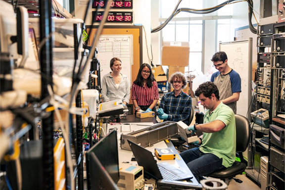
Team members Paige Northway, Anika Hidayat, John Correy and Eli Reed (back row, left to right) watch in June as Henry Martin of Nanoracks does a “fit test” to ensure that the satellite fits inside the silver box. The digital clock on the wall counts down the days, minutes and seconds until launch. Photo is courtesy of Dennis Wise/University of Washington.

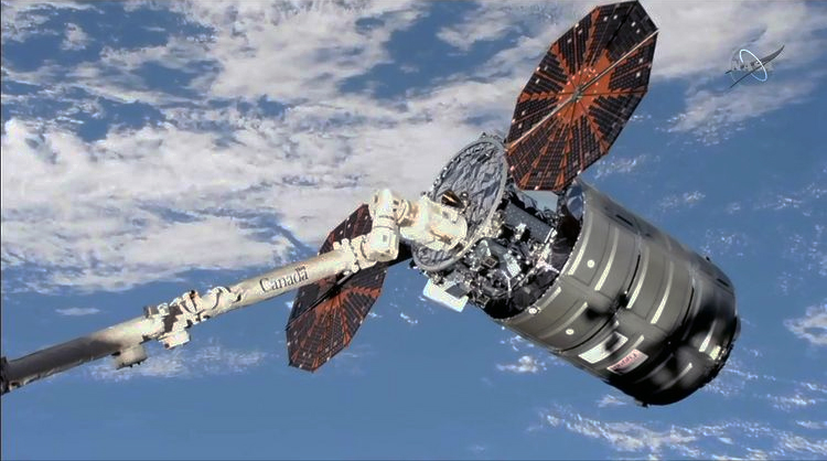
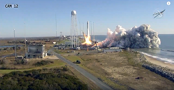
HuskySat-1 is one of seven student-built satellites from around the country scheduled to launch at 9:30 a.m. Eastern time Saturday, November 2, from NASA’s Wallops Flight Facility on the Virginia coast.

HuskySat-1’s last moments on Earth will be broadcast live on NASA TV. The satellites are hitching a ride on the Cygnus cargo spacecraft, whose first stop will be the International Space Station to resupply astronauts and swap out materials. In early 2020, the spacecraft will leave the station and fly up to an altitude of about 310 miles (500 kilometers), where a NASA engineer will eject the student-build satellites.

The UW creation is a type of cubesat, a smallsat that measures exactly 10 centimeters (about 3 inches) along each side. HuskySat-1 is a “three-unit” system, meaning it’s the shape of a stack of three cubesat-sized blocks.


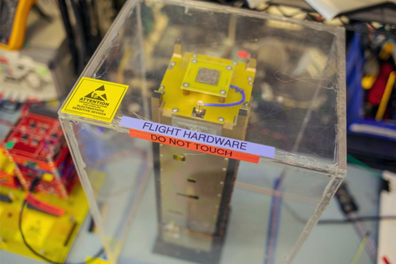
HuskySat-1 sits under protection in the UW satellite lab in June, as it prepared to leave on its journey to Virginia and then to LEO Photo is courtesy of Dennis Wise/University of Washington.

These miniature satellites were first created as a way for engineering students to test software with smaller, cheaper devices they could build from start to finish in a few years. However, the devices are growing in popularity, with Planet and other companies now using smallsats for a variety of commercial ventures.

NASA’s CubeSat Launch Initiative helps students and nonprofit groups launch these instrument systems into space. The Washington State University satellite, CougSat-1, is scheduled to launch in October 2020.

The UW satellite weighs just under 7 pounds (3.14 kilograms) and required five years to design and build. Undergraduate and graduate students from aeronautics and astronautics, mechanical engineering, computer engineering, Earth and space sciences, physics and other departments spent hundreds of hours building the system in the Husky Satellite Lab.


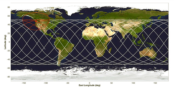
White lines show the satellite’s projected travel path, orbiting at an angle of 51.6 degrees from the equator. The antennas at the UW will be able to communicate with HuskySat-1 when it flies inside the red circle. Image is courtesy of Paige Northway/University of Washington.

Its trip into low-Earth orbit is organized by Nanoracks, a Texas company that, like Spaceflight Industries of Seattle and other businesses, coordinates smaller groups to provide access to launch vehicles. HuskySat-1 will orbit at an angle of 51.6 degrees, traveling between 51.6 degrees north and south, at an altitude of 310 miles (500 kilometers) and at more than 4 miles (7 kilometers) per second. Once the students locate their satellite, they will be able to predict its travel path.

After extensive testing and final checkouts this summer, the satellite was hand-delivered to the Nanoracks facility in Houston, where it was placed into the box that will carry it to space.

Three antennas installed on the roof of Johnson Hall will allow students to get information like position and altitude and send instructions to the satellite as it passes overhead. A camera built in collaboration with students at Raisbeck Aviation High School in Tukwila, Washington, will send back grainy, black-and-white photos of Earth. Students will also be able to control the satellite’s camera and thruster remotely.

Robert Winglee, a professor of Earth and space sciences and the team’s faculty adviser as director of the UW Advanced Propulsion Lab, said these students have gained firsthand experience on what is required to build and launch a satellite and aerospace companies have already snapped up many of them. Meanwhile, the UW is making its first steps to a continuing hardware presence in space. What more could anyone wish for?

Paige Northway, a UW doctoral student in Earth and Space Sciences who has been involved since the project’s inception, added that it will be exciting once it’s in orbit. To her, the completion will be when we data is received from the satellite and are returned to the spacecraft.

Team member Anika Hidayat, a senior in mechanical engineering, noted that a lot of information is taught in classes, but only in a hands-on environment can you experience things like design, integration of subsystems, project management and documentation.

Some of the student-built parts will still be in test mode. A custom-built thruster uses sparks to vaporize small amounts of solid sulfur as a propellant. The thruster will fire about 100 times as the satellite passes over Seattle, only enough thrust to provide a slight nudge. A high-bandwidth communications system built by former graduate student Paul Sturmer, now at Blue Origin, transmits at 24 Gigahertz, allowing the satellite to quickly send reams of data. That system will send down a test packet from space.

The UW group will control HuskySat-1 for three months. In the spring, it will transfer ownership and responsibility to AMSAT, the Radio Amateur Satellite Corporation, which provided the main communication system. The satellite will begin to lose altitude in about three years and will burn up as it re-enters Earth’s atmosphere. (NASA requires that all such objects de-orbit within 25 years.)

HuskySat-1 grew out of a special topics course in the UW Department of Earth & Space Sciences. In 2016 members formed a registered student organization, the Husky Satellite Lab at UW.

As the Husky Satellite Lab wraps up this half-decade-long effort it plans to next tackle a NanoLab project — a partly prebuilt system that can be adapted to conduct experiments in microgravity — for travel aboard a Blue Origin vehicle. Students plan to complete that project by spring of 2020.

HuskySat-1 was supported by a NASA Undergraduate Student Instrument Project award, which funded the satellite’s development and launch with a private space contractor. The team also was supported by NASA, the Washington NASA Space Grant Consortium, the UW and several companies that provided equipment for the satellite and antenna.

Article source: Journalist Hannah Hickey, University of Washington News

Smallsat Industry Projected by Allied Market Research to Garner $3.63 Billion in 2018

Allied Market Research has published a report entitled, “Small Satellite Market by Type (Minisatellite, Microsatellite, Nanosatellite, Pico-Satellites, and Femto Satellites), Application (Imaging and Earth Observations, Satellite Communications, Science & Explorations, Technology Development, and Space Situational Awareness), and End-User (Civil & Commercial and Government & Defense): Global Opportunity Analysis and Industry Forecast, 2019–2026.” As per the report, the global smallsat industry garnered $3.63 billion in 2018 and is estimated to reach $15.69 billion by 2026, growing at a CAGR of 20.1% from 2018 to 2026.

Surge in demand for high-resolution imaging services and technological advancements drive the growth of the global small satellite market. However, lack of dedicated smallsat launch vehicles hinders the market growth. On the other hand, high demand from emerging economies and increase in government investments create new opportunities in the industry.

Based on product type, the microsatellite segment accounted for the major share, contributing to more than one-third of the global small satellite market. This is due to companies operating large satellites are looking for lighter and cost-effective platforms. However, the nanosatellite segment is expected to register the highest CAGR of 20.7% from 2018 to 2026.The imaging and earth observation segment to dominate by 2026

Based on application, the imaging and Earth Observation (EO) segment held the highest share in terms of revenue in 2018, contributing to more than one-third of the total small satellite market. This is due to the significant increase in demand for small satellites in imaging application from the U.S., Russia, and China. However, the satellite communication segment would register the fastest growth rate, with a CAGR of 20.4% from 2018 to 2026.

Based on end-user, the civil and commercial segment held the highest share in terms of revenue in 2018, contributing to more than three-fifths of the total smallsat market. This is due to their low cost and lightweight. There has been an increased demand for these satellites in LAMEA, and Asia. Furthermore, this segment would register the fastest growth rate, with a CAGR of 20.2% from 2018 to 2026.

Based on region, Asia-Pacific is estimated to grow at the highest CAGR of 20.5% from 2018 to 2026, owing to the presence of countries such as China, India, and Japan. On the other hand, North America accounted for more than half of the total smallsat market in 2018. This is attributed to the presence of key players, the presence of all the companies of the value chain so less dependency on imports, and high demand for imaging and earth observation application.

Inquire more about this report @ www.alliedmarketresearch.com/purchase-enquiry/1951

MOU Signed Between Swedish Space Corporation and the German Aerospace Center for Micro Launcher Engine Development

Swedish Space Corporation (SSC) and German Aerospace Center (DLR) have signed an MOU for the development of test facilities for micro launcher engine and stage tests.

The agreement will include exchanging facilities, knowledge and staff, providing Europe with the infrastructure for the entire range of rocket tests, including early stage “higher risk” tests, as well as increasing the capacity to provide for more companies to test their products.


The MOU was signed by Stefan Schlechtriem, Director of the DLR Institute of Space Propulsion (left) and Stefan Gardefjord, CEO of SSC (right), at the recent International Astronautical Congress (IAC).

Photo is courtesy of the companies.

Through this collaboration, the testing capabilities at Lampoldshausen in Germany and Esrange Space Center in Sweden can be optimized.

Stefan Gardefjord, CEO SSC, said there has been a shortage of suitable test sites for early stage and short preparation tests for the next generation of sounding rockets, micro launchers and reusable rockets. By combining the firm’s testing capabilities with DLR, SSC can provide Europe with more testing capability, thus strengthening the development of European space programs.

Professor Stefan Schlechtriem, Director of the DLR-Institute of Space Propulsion, added that the organization has found the correct partner for the joint planning and implementation of a test stand for hybrid and liquid-fuel engines at Esrange Space Center (ESC). DLR Lampoldshausen is contributing its unique expertise as a European testing and development location for all liquid chemical space engines to the development of the next generation of engines. This collaboration will enable us to bring together the expertise of the institutions. With the intensified cooperation between SSC and DLR, the two partners will provide the infrastructure in Europe for the entire range of engine tests, including tests at an early stage of development, thus increasing the portfolio of testing opportunities in Europe.

The NexGen IoT Animal Tracker Shepherded Out from FindMy with Globalstar LEO Satellite Connectivity

Globalstar Europe Satellite Services Ltd., a wholly owned subsidiary of Globalstar, Inc. (NYSE American: GSAT) has announced that the company’s FindMy IoT animal tracking pioneer has launched its next-generation tracker — the FindMy e-Bell Model 2 collar is more robust, smaller and lighter, and now features Bluetooth for easy set-up and a longer-life replaceable battery for lower maintenance.

As FindMy marks its 10 year partnership with Globalstar, and with more than 45,000 collars deployed in the field, FindMy collars have transmitted 20 million IoT tracking messages by satellite, enabled by Globalstar’s STX3 chipset and its worldwide fleet of LEO satellites. This data allows farmers to reliably monitor and protect their valuable herds wherever they roam, including regions beyond the reach of mobile phone networks.

The appeal of FindMy is such that it has even attracted customers whose farms are in locations with good mobile coverage – this is due to the price competitiveness of FindMy’s satellite-enabled solution, and the highly functional and user-friendly app and user interface which FindMy provides.

FindMy has spent the last two years designing and engineering the new animal collar, which will be available from Spring 2020. Additional new features include a custom antenna that adds extra assurance of successful message transmission, and a new app that makes it easy for farmers to configure and customize the collar’s transmission settings. The e-Bell Mark 2 is easily self-configurable for farmers and the new industrial-grade FindMy devices are engineered to meet military-level SATCOM standards for robustness in all weather conditions.

Enhanced software can now deliver a complete snapshot update of the herd/flock location at particular times of day specified by the farmer dependent on when they head out to the hills to check on the animals. The system also includes an improved accelerometer sensitive enough to detect whether an animal is in distress, such as if it is frightened or being chased.

The STX3’s small size, ruggedness, long battery life, and ease of integration, as well as its competitive price, remain key compelling features for FindMy. It makes it possible for farmers to geo-fence livestock, helping them to monitor animals to ensure they graze only in designated areas, and to locate those that have escaped or are injured.

It also enables farmers to optimize their stock, ensure the animals have adequate food and water, while mitigating against disease and predation. FindMy’s data trail empowers farmers to analyze areas of best grazing and they can proactively manage grazing for future seasons.

FindMy’s custom user interface alerts farmers and herd managers when an animal has not moved for some time. With FindMy’s GPS data, they can identify exactly where to go to investigate, saving valuable time and resources. Farmers deploying the collars report a significant reduction in animal loss, with a consequent direct positive impact on their business.

Norwegian sheep farmer Halvor Mjoen originally founded FindMy in 2009 to support his fellow sheep farmers whose flocks graze fence-free in the mountains and often range across borders into Sweden, Finland as well as Russia. In addition to monitoring sheep, FindMy has also been adopted by reindeer-herders, many with ancestral heritage from the indigenous Sami communities in the far North, whose livestock range across the Arctic Circle. FindMy’s reputation has further grown internationally and the system is now used as far away as on cattle ranches in South America.

Mjoen said the company’s success was resultant of listening carefully to customers, understanding their everyday operations, their pain points and working to deliver what they really need. The company’s close partnership with Globalstar, with its reliable, functional and cost-effective satellite technology, has played a huge role in the firm’s achievements.

Mark O’Connell, Globalstar EMEA GM noted that FindMy is a perfect example of design, engineering and industrial creativity, and amply demonstrates how satellite technology and the Internet of Things can be harnessed to powerfully solve real world problems. The company congratulates FindMy on its next-generation solution that will help more farmers improve the welfare of their livestock, and enhance their businesses, across the Nordic region and beyond.