Tokyo Tech’s Deep Learning Attitude Sensor Delivers Real-Time Image Recognition from Satellites’ Orbit

Researchers at Tokyo Institute of Technology (Tokyo Tech) have developed a low-cost star tracker and Earth sensor made from commercially available components. The star tracker is designed for use with micro-satellites in handling calibration observations, operation verification tests, and long-term performance monitoring during orbit.

Embodying the concept of edge computing, the Earth camera performs image recognition while in orbit using a simple AI that identifies land use and vegetation distribution. Utilizing the acquired topography data, assessments can also be conducted using a novel 3-axis attitude estimation method. The star tracker and Earth sensor are installed on the Japan Aerospace Exploration Agency’s (JAXA) Epsilon-4 rocket, scheduled for launch on January 17, 2019 from the Uchinoura Space Center in Kagoshima Prefecture.
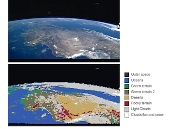

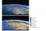
Example of vegetation/land-use identification using an Earth image
from the ISS

Research Goals

To perform functions such as communicating with ground stations and directing solar cell paddles toward the sun for power and temperature control, satellites use attitude sensors to determine their orientation (attitude). The Tokyo Tech research group led by Assistant Professor Yoichi Yatsu has developed a star tracker and an Earth sensor that uses deep learning to determine attitude in space. With no ground to distinguish directionality, the device constantly tracks multiple fixed stars to achieve high accuracy, while the Earth sensor performs attitude estimation based on images of the Earth.

This Deep Learning Attitude Sensor (DLAS) was developed with three goals in mind. The first is to demonstrate that a low-cost star tracker made from inexpensive, high-performance commercially available components can effectively operate in space. The plan is to capture images of stars in orbit under various conditions to calibrate the sensor system and determine attitude based on novel algorithms, and demonstrate long-term operation with a test period of one year.

The second goal is to conduct orbital testing of real-time image recognition using deep learning. The Earth is photographed using two compact visible light cameras incorporated in the baffle of the star tracker. The 8-megapixel images taken are processed in about 4 seconds using a specially developed high-speed, lightweight image identification algorithm. Recognition of vegetation and land use is performed over nine categories, including green terrain, deserts, oceans, clouds, and outer space. This will be the first demonstration of real-time image recognition in space using deep learning (See figure). In orbit, more than 1,000 images are taken as learning data and transferred to the ground for use in satellite image application tests. The third goal is the application of this image identification technology, and the evaluation of the technologies for estimating 3-axis attitude using land features obscured by clouds and comparing it with map data prerecorded in the onboard computer (See figure).

Hardware development for DLAS completed in April 2018 and was incorporated into the Innovative Satellite Technology Demonstration-1 (RAPIS-1) developed by JAXA . After about six months of system environment testing and operation rehearsals, it will be launched from the JAXA Uchinoura Space Center in Kagoshima Prefecture using Epsilon-4 on January 17, 2019, and will enter into Sun-synchronous orbit at an altitude of 500 km. DLAS operation is scheduled to start after completion of the RAPIS-1 checkout, and after confirming initial operation, each sensor system will undergo calibration for about one month. Afterwards, it will enter into mission operation for one year.

JAXA entrusted development of the RAPIS-1 satellite / control system and satellite operation to Axelspace Corporation, which is a startup company established by people involved in the development of nanosatellites at the University of Tokyo and Tokyo Tech. This marks a major turning point in Japanese space development, which until now had been led by major electronics manufacturers, and will be a memorable flight operation for those related to private space development, which was “palm size” at universities fifteen years ago.

Background

It has been fifteen years since the world’s first CubeSats, CUTE-I and X-XI developed by Tokyo Tech and the University of Tokyo, were launched in 2003. Nanosatellites were initially for education purposes. After 2010, these began to be actively used for commercial space projects. Today, more than 200 are launched annually, establishing a new global 1-billion-USD space industry. Since Engineering Technology Demonstration Satellite CUTE-I, research groups from the Kawai Laboratory and Matsunaga Laboratory at Tokyo Tech are aiming for nanosatellite space science observation, and have been leading the world’s development of the nanosatellites, by conducting the development, launch, and operation of three nanosized observation satellites(Note) (Cute-1.7+APD, Cute-1.7+APD Unit 2, and TSUBAME) 

Research Details

In recent years, due to the development of communication networks (Internet) and computer technologies for connecting satellites with the whole Earth, the new field of discovery known as “time domain astronomy” has opened, which involves research on short-term astronomical phenomena that suddenly appear and disappear. The symbolic target is the gravitational wave phenomenon discovered in August 2017, its electromagnetic wave counterpart was discovered through observation of radio/infrared/optical telescopes, observation satellites, and neutrino detectors all over the world observed simultaneously in response to the detection alert of the position of the gravitational wave telescope. Dr. Yatsu’s team plans to monitor a super wide field of 100 square degrees with UV light for which there are almost no observation examples, and conduct research with the aim of discovering initial activity of short-term astrophysical phenomena such as gravitational wave sources and unknown astrophysical events.

Satellites are needed since most UV light is blocked by the atmosphere, but in order to obtain sharp photographs of faint stars, high attitude stability is required. In addition, it is difficult to instantaneously transfer all image data back to the ground due to limitations in satellite communication speed. Therefore, in order to have detailed observation using a combination of the above-mentioned terrestrial telescopes, practical measures need to be developed including transmitting only analysis results such as the accurate position and brightness of a target astronomical object by having image analysis performed in the satellite. To accomplish such an advanced observation mission, it was necessary to acquire a highly accurate star tracker, a highly advanced on-board computer that can be mounted on a satellite, and an automatic image analysis technique that utilizes these.

Astronomical observations from a space telescope require data processing programs such as high-accuracy attitude calculation based on the assumption of cosmic radiation removal, star image detection, star alignment pattern matching, noise contamination, etc., that can also be used as a star tracker, which is an attitude sensor for artificial satellites. Unfortunately, there is currently a lack of attitude system suppliers for nanosatellites in Japan. Therefore, the research team has been developing actual equipment with a view toward commercialization of on-board component development.

On the other hand, ground-based image recognition tests were originally inspired by ground-based weather identification tests. Currently, the Kawai Laboratory has set up robotic telescopes with a diameter of 50 cm in Yamanashi Prefecture and Okayama Prefecture to observe gravitational wave phenomena, gamma-ray bursts, etc. However, observation was often suspended because the weather in Japan is unstable. Therefore, research on a cloud identifier based on deep learning was conducted to improve observation efficiency. The cloud identifier developed in cooperation with Tokyo Tech School of Computing professors Koichi Shinoda and Nakamasa Inoue achieved extremely high accuracy even in the initial prototype stage, and it was believed that it could be applied to instantaneous image identification for orbiting satellites, prompting this study.

Until now, analysis of satellite images using AI generally referred to carefully analyzing large numbers of images accumulated in data servers on the ground using supercomputers, but real-time image recognition on orbiting satellites, i.e. at the computing “edge”, has the potential to greatly change the value and operation of the nanosatellite platform. For example, there is a huge amount of information that quickly loses its value if it cannot be quickly determined, such as that in defense, disaster monitoring, and capturing debris. This research was embarked upon to achieve autonomous detection by satellites, in place of human eyes. 

Future Development

(1) Advancing the state-of-the-art in space science

Development of observation satellites aimed at the world’s first super wide field ultraviolet survey observation is being carried out through the inheritance of satellite attitude measurement technologies acquired through DLAS and advanced image processing technologies using onboard computers.

In cooperation with the NASA Jet Propulsion Laboratory at the California Institute of Technology, the team plans to employ an ultra-sensitive backside illuminated CMOS imager optimized for ultraviolet color band to achieve required sensitivity. The data processing system, optical system, and satellite bus system will be developed by Tokyo Tech. In parallel with equipment development, discussions of observation strategies are being promoted at Tokyo Tech, Konan University, Tohoku University, the University of Tokyo, California Institute of Technology, Aoyama Gakuin University, and others. According to the current plan, R&D is progressing with a launch goal of 2022.

(2) Commercialization by Tokyo Tech Space Startups

As work on DLAS progresses, various findings are being obtained that can only be learned through actual equipment development such as the star tracker design method, manufacturing techniques, test techniques, ground calibration tests, star matching algorithms, and embedded software. Commercialization of these findings will be actively promoted. Tokyo Tech venture Amanogi is proceeding with the manufacture and sale of spacecraft mounted devices. This startup has obtained subsidies from NEDO supporting a commercial version of the star tracker, and has also obtained seed financing from the private venture capital companies Innovations and Future Creation Inc. and Darma Tech Labs. Utilizing development knowledge and flight data from DLAS, the goal is to provide inexpensive but reliable satellite-mounted products to the market at an early stage. In the product version, development of a star tracker for CubeSats is being considered to meet demand by private space business operators, and it was decided to install a demo device on Innovative Satellite Technology Demonstration-2. The present goal is to start accepting orders in 2020.

(3) Forming bases for sharing knowledge and commercializing development technologies and test platforms, etc.

Conventional space equipment and system designs rely on computer technologies that are 10 to 20 years behind what is used on the ground in order to ensure high reliability. However, when it comes to nanosatellites where many are released within a short cycle, state-of-the-art IoT technology and computational systems such as DLAS can be applied. It is projected that a combination of variable structures such as computer science, extension, and development are needed to overcome the limitation on payload size, the one drawback of nanosatellites, and realize more advanced space utilization. The research team led by Professor Saburo Matsunaga of Tokyo Tech will promote the formation of a development base for “smarter” space systems with an eye toward such space equipment.

In this project, the aim is to realize smart space equipment by 1) carrying out development of attitude/observation sensors that use machine learning based on the application of DLAS information, lightweight and highly rigid contractible booms and arrays, satellite-mounted equipment such as deployable antennas for high-speed communication, and a “HIBARI” nanosatellite with a variable shape function that verifies a new attitude control method capable of achieving both quick change and high orientation stability, and 2) share orbital observation data and processing technology, and provide services such as shared use of test operation facilities such as a cobalt 60 irradiation chamber. Further aims are to support creation and development of new business by 3) creating industry-academia cooperation models and industry-academia networks, and 4) supporting young researchers through hands-on learning. This initiative was adopted as the MEXT commission on the promotion of aerospace science and technology “Research and development center for smart space equipment and systems that create a new space industry” (started August 31, 2018, scheduled for completion at the end of Fiscal 2020), and activities started. As the main executing institution, Tokyo Tech (Saburo Matsunaga (representative), Hiroshi Furuya, Yoichi Yatsu, and Noriyosu Hayashizaki) is promoting the project jointly with Nihon University (Yasuyuki Miyazaki), TechSol (Kazuyuki Nakamura), SAKASE ADTECH (Akihito Watanabe), and Amanogi (Hiroshi Kudo), and technical support and feedback for future direction are received from many other research collaborators (participants being recruited from time to time) consisting of universities, research institutes, and companies.

About Tokyo Institute of Technology 

Tokyo Tech stands at the forefront of research and higher education as the leading university for science and technology in Japan. Tokyo Tech researchers excel in fields ranging from materials science to biology, computer science, and physics. Founded in 1881, Tokyo Tech hosts over 10,000 undergraduate and graduate students per year, who develop into scientific leaders and some of the most sought-after engineers in industry. Embodying the Japanese philosophy of “monotsukuri,” meaning “technical ingenuity and innovation,” the Tokyo Tech community strives to contribute to society through high-impact research. https://www.titech.ac.jp/english/

Tokyo Institute of Technology


Satellogic with China Will Launch 90 Earth-Observation Satellites … Remap Earth at 1-Meter Pixel Each Week

An international space venture called Satellogic says it will have 90 satellites launched by a Chinese company to create an Earth-observing constellation.


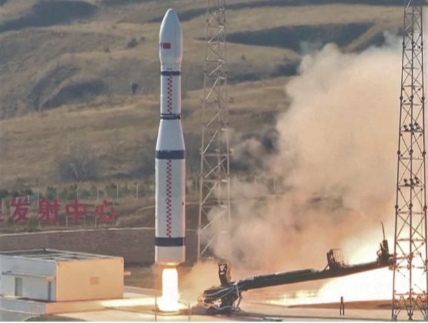
China’s Long March 6 rocket lifts off from the Taiyuan Satellite Launch Center in 2017. (CCTV via YouTube)

The first launch by the China Great Wall Industry Corp. under the newly announced deal, scheduled for later this year, will deliver 13 satellites to low Earth orbit on China’s Long March 6 rocket, Satellogic said today in a news release.

Satellogic’s constellation seems likely to compete with the remote-imaging satellite constellations operated by San Francisco-based Planet and Seattle-based BlackSky. The company promises to remap Earth at 1-meter pixel resolution every week and dramatically reduce the cost of high-frequency geospatial analytics.n

“We want to help solve the world’s most pressing problems by building an accurate and up-to-date picture of our planet and the many forces that reshape it every day,” Satellogic founder and CEO Emiliano Kargieman said. “This agreement is a major step in realizing that vision.”

Financial terms of the deal were not disclosed.

China Great Wall was established in 1980 with authorization from the Chinese government to provide commercial launch services and satellite systems as a subsidiary of the China Aerospace Science and Technology Corp. The company has already launched a demonstration nanosatellite for Satellogic, as well as five larger satellites, and it’s due to send three more spacecraft into low Earth orbit this year under the terms of an earlier agreement.

“We’re proud to extend our highly successful working relationship with Satellogic,” Gao Ruofei, executive vice president of China Great Wall, said in today’s news release. “Satellogic’s constellation will introduce a new era of affordable Earth observation, just as the LM-6 will open new opportunities for the global space industry.”

U.S.-based satellite operators are generally barred from having their payloads launched on Chinese rockets. However, Satellogic’s headquarters and development facility is located in Buenos Aires, Argentina, and its satellite assembly facility is in Montevideo, Uruguay.

The company also has a data technology center in Barcelona, Spain; a product development center in Tel Aviv, Israel; and a business development center in Miami. Satellogic’s newest branch office, in Beijing, will focus on constellation customization, data services and industrial applications.

Satellogic says it employs more than 150 satellite engineers, solution specialists and experts in artificial intelligence. In 2017, the company raised $27 million in a Series B funding round led by Tencent, a Chinese investment holding company.

Like Planet and BlackSky, Satellogic is targeting satellite imaging applications in fields such as disaster response, oil and gas prospecting, infrastructure monitoring, forestry and agricultural crop assessment.

By Alan Boyle for GeekWire

D-Orbit Welcomes ESA and Italian Space Agency Smallsat Development Contract

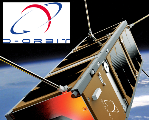
The European Space Agency (ESA) awarded D-Orbit SpA with the General Support Technology Program (GSTP) contract n°4000126167 titled “Development of a Precise In-Orbit CubeSat Deployer” — the GSTP is an optional ESA program to enable the European space industry to develop leading edge space technology.

Under the GSTP, ESA partner organizations — the Italian Space Agency (ASI) in this instance — allocate additional funding for a project. The program’s mission is to convert promising engineering concepts into mature products, bridging the gap between research laboratories and commercial space missions.

Executive Comments

Renato Panesi, D-Orbit’s CCO, said that the 2.6 million euros contract covers the study, specification, design, production, and qualification of a small satellite with the ability to transport a batch of CubeSats to orbit, and deploy each one of them independently over the course of the mission, changing orbit and attitude before each deployment to accommodate the needs of the client. The satellite will feature modular and configurable dispensers, designed to accommodate several combinations of CubeSats of different form factors. Each CubeSat will be connected to the satellite bus until deployment, receiving power and data, enabling operators to checkout their CubeSats during the pre-launch phases and before their release into orbit.
     He continued that this launch and deployment solution will provide a single interface towards the launcher authorities, a simplification of satellite integration for CubeSat operators, and a precision deployment to orbit that will significantly reduce satellite dispersion time. D-Orbit has already gained a foothold on the development of this CubeSat launch and deployment technology with its ION CubeSat Carrier, a free-flyer CubeSat dispenser whose first launch is slated for mid 2019.

Lorenzo Ferrario, D-Orbit CTO, added that the first phase of the contract was started on January 1st, 2019, and will last five months and will lead to the finalization of the design. The second phase, which will last 11 months, will end with the delivery of the fully qualified spacecraft. The launch is slated for the second half of 2020.

ResearchAndMarkets.com’s Small-Satellite Launch Services Market – Forecast to 2030 … Provides Updates

Small satellites are the hot button issue and much has been written including forecasts of the future for these miniatures. Most recently ResearchAndMarkets.com has released an update for the “Small-satellite Launch Services Market, Quarterly Update Q3 2018, Forecast to 2030”.

As ResearchAndMarkets.com explain their report…

Small-satellites are at the spotlight of the evolution of space industry. Small-satellite ecosystem is expanding at an increasing pace, with new entrants offering new space solutions and existing players expanding their portfolio by investments in the small-satellite value chain. It becomes very important to investigate the past and current state of the small satellite market and forecast the future scenarios.

Many small satellite constellation operators have advanced in their development processes and will generate continuous and recurring launch demand for their constellation installation and replacement missions. At present, nearly all small satellites use the rideshare capacity as a secondary payload on the existing launch vehicles. This makes their project schedule and mission requirements dependent on the primary payload.

Moreover, the existing rideshare capacity will not be sufficient to address all the small satellite launch demand in future. Many incumbent and new players have sensed the upcoming small satellite demand and have started planning for providing dedicated services and launch flexibility to the small satellite operators, in order to capture the future small satellite launch market.

What makes this report unique?

The report tracks the changing dynamics every quarter and updates the forecast based on the latest events. The report exposes the readers to the latest forecast numbers and the major changes, empowering them to the most informed decision making. A bottom up and detailed approach is applied to forecast the small satellite launch demand. The study defines multiple forecast scenarios based on the maturity of satellite operators.

More than 250 operators across the user segments are considered for the forecast. A large number of small satellites, payload mass, and launch revenue have been forecast on the basis of defined scenarios, satellite mass classes and user segments. The study also includes the launch capacity forecast for both rideshare and dedicated launch services segment and analyses the alignment between the small satellite launch demand and capacity supply.

Key Topics Covered

1. Executive Summary

2. Definitions and Segmentations

3. Major Changes with Respect to Q2, 2018 Forecast

4. Small-satellite Launch Demand Forecast by Scenarios, User Segments and Mass Classes (Number of Satellites)

5. Payload Mass Forecast by Scenarios, User Segments and Mass Classes

6. Launch Revenue Forecast based on Launch Demand by Scenarios, User Segments and Mass Classes

7. Launch Capacity Forecast, Rideshare and Dedicated

8. Small-satellite Launch Demand Versus Launch Capacity Supply

9. Key Small-satellite Events and Developments in Q2 2018

10. Conclusions

For more information about this report  


UPDATE: Arianespace Soyuz to Launch the CNES EyeSat Smallsat and to Deliver ANGELS to Space

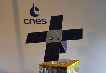
Arianespace and the French CNES have signed a launch services contract for the EyeSat smallsat, an astronomy mission that will study zodiacal light as well as image the Milky Way.

EyeSat is a triple cubesat-sized smallsat that is designed to study the zodiacal light and image the Milky Way and has three main objectives:

  • Scientific, by observing the zodiacal light in the visible bandwidth, in both polarized and non-polarized modes; and taking a thorough – and global image – of the Milky Way in color.
  • To demonstrate new satellite technologies. These technologies were developed through research efforts by CNES, and are considered sufficiently mature to be incorporated on EyeSat.
  • To train students in space engineering professions.

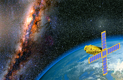
Artistic rendition of the EyeSat smallsat.
Image is courtesy of CNES.

The EyeSat nanosatellite is being financed and developed by the French CNES (Centre National d’Etudes Spatiales) space agency within the scope of the Janus project (Jeunes en Apprentissage pour la réalisation de Nanosatellites des Universités et des écoles de l’enseignement Supérieur), designed to encourage students in universities and engineering schools to develop their own smallsats.

EyeSat will be launched in 2019 as an auxiliary payload with the COSMO-SkyMed Second Generation (CSG 1) and CHEOPS satellites from the Guiana Space Center (CSG) aboard a Soyuz launcher.


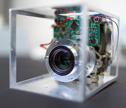
Photo of the IRIS telescope for the EyeSat mission.
Photo is courtesy of CNES.

The smallsat is in the form of a triple (3U) cubesat and is fitted with an instrument called IRIS, which is a small space telescope. The smallsat will have a mass at liftoff of approximately 8 kg. and will be placed in Sun-Synchronous Orbit (SSO) at an altitude of about 500 km.

Executive Comments

Following the contract signature, Marie-Anne Claire, Director of Orbital Systems at CNES, said: “Thanks to the EyeSat triple Cubesat, CNES will be able to test in orbit a dozen new miniaturized technologies developed through our research and technology program. We also helped train more than 250 students in space engineering professions. CNES is very pleased that EyeSat will be orbited by Arianespace from the Guiana Space Center.”

Stéphane Israël, Chief Executive Officer of Arianespace, added, “Arianespace is honored to have been chosen by CNES to launch the EyeSat triple Cubesat dedicated to science. Once again we have proven our ability to guarantee independent and competitive access to space for Europe, encompassing satellites of all sizes, thanks to our flexible service offering and our versatile family of launchers.”

There’s more… the EyeSat contract for Arianespace is not the only business move just signed… The two firms have also signed a launch contract for the first smallsat completely built by French industry, called ANGELS (ARGOS Néo on a Generic Economical and Light Satellite).


The ANGELS smallsat.
Photo is courtesy of CNES.

ANGELS will be launched as an auxiliary payload with the COSMO-SkyMed Second Generation (CSG 1) and CHEOPS satellites by a Soyuz rocket in 2019 from the Guiana Space Center, Europe’s Spaceport in French Guiana (South America). This mission is jointly financed and developed by the French CNES (Centre National d’Etudes Spatiales) space agency and NEXEYA, an innovative industrial group active in the aerospace, defense, energy, rail and automotive markets.

The satellite will be fitted with a miniaturized ARGOS Néo instrument, which is 10-times smaller than the equivalent previous-generation device. The instrument collects and determines the position of low-power signals and messages sent by the 20,000 ARGOS beacons now in service worldwide. Two project teams — CNES and NEXEYA for ANGELS, and CNES, Thales Alenia Space and Syrlinks for ARGOS Néo — are working together on this French space project.

The ANGELS smallsat will have a liftoff mass of approximately 30 kg. at launch, including its separation device, and will be positioned in Sun-synchronous orbit at an altitude of more than 500 km.

Executive Comments

Marie-Anne Clair, CNES Director of Orbital Systems,said that CNES has been committed to miniaturizing satellites for a number of years, in particular through the Proteus mini-satellite and Myriade micro-satellite programs. ANGELS pursues and amplifies this initiative, by paving the way for French industry to build operational nanosatellites within the NewSpace environment.

Stéphane Israël, CEO of Arianespace, added that Arianespace is proud of winning this new contract from CNES to launch ANGELS. Against the backdrop of a dynamic small satellite market, this first nanosatellite from French industry reflects the availability of Arianespace’s services and its ability to adapt to the needs of the market.

Newtec to Provide Kacific with Dialog® VSAT Platform for Kacific1 Satellite

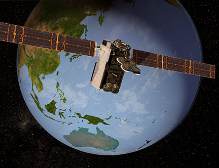
Newtec‘s Dialog® VSAT multi-service platform has been selected by broadband satellite operator, Kacific, for that firm’s new, High Throughput Satellite to significantly expand that firm’s broadband service delivery in underserved areas of South East Asia, New Zealand and the Pacific Islands — the initial contract is for $10 million of Newtec Dialog hubs and this is expected to result in further terminal procurements totaling several million units during the first years of service.


Artistic rendition of the Kacific1 satellite. Image is courtesy of Kacific.

Kacific1 will deliver affordable, high-speed internet broadband to telecommunications companies, internet service providers and governments throughout the region, with Newtec’s Mx-DMA® return technology providing the highest possible bandwidth efficiency. The Kacific1 satellite features 56 high power subscriber spot beams, each with the capability to provide targeted capacity at high speeds.

Kacific services enable access to high demand applications, such as community internet access and mobile backhaul, that will help stimulate socio-economic activity throughout the region. Public institutions will benefit from dedicated services including healthcare, education and civil defense, in areas that are beyond the economical reach of terrestrial infrastructures in most of Kacific’s coverage areas. Kacific was recently presented with the Better Satellite World award for its focus on connecting underserved populations.


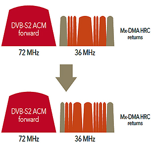
The Mx-DMA waveforms. Image is courtesy of Newtec.

Newtec’s next-generation Mx-DMA return technology incorporates the best features of MF-TDMA and SCPC technologies to provide dynamic bandwidth allocation with the highest level of efficiency. Mx-DMA return technology on the Newtec Dialog platform uniquely adjusts the frequency plan, the symbol rate, the modulation, coding and power in real-time for every terminal in the satellite network in response to traffic demand and Quality of Service (QoS) changes.

Executive Comments

Christian Patouraux, CEO and Founder of Kacific, said the Kacific HUB, based on the Newtec Dialog multi-service platform, is a pivotal part of the satellite network. The company selected Newtec because the firm demonstrates the highest performance and ability to offer the highest link efficiencies that are required for Kacific’s Ka-band spot beam system. The company also been impressed with other unique features offered by Newtec, such as the Satellite Network Calculator, which enables the company to tailor new services in a highly efficient and fast-to-market manner, which will only help ensure the reliability and enhance the quality of Kacific services to customers.

Thomas Van den Driessche, CEO at Newtec, added that in partnering with Kacific, the company is strengthening the firm’s presence in South East Asia and the Pacific. This project bridges the digital divide to people in regions that have never before had access. Among many other features, Newtec’s Satellite Network Calculator has an acute ability to provide valuable insight into the performance of the network. The product use in a multi-beam satellite network such as this will allow Kacific to harness these insights to optimize future deployments and add value for their regional partners and customers.

Concerns Regarding the Planned SpaceX Constellation…

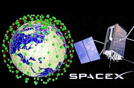
The Advanced Television infosite has posted an article that SpaceX is planning to launch thousands of satellites into various orbits in order to deliver broadband services to the whole planet — the first satellites will launch later this year, but there are some growing doubts.

The influential Institute of Electrical & Electronics Engineers (IEEE) in its ‘Spectrum issue talks about glitches with both of SpaceX’s initial prototype craft, launched almost a year ago, and which failed to reach their target orbits (of 1125 kms).

Spectrum’ quotes Tim Farrar (of TMF Associates) who said that one of the satellites was not able to relocate itself at all from its initial orbit of 511 kms, while the second satellite “tried to maneuver without success.

The IEEE’s report author Michael Koziol also cites anxieties about SpaceX’s overall chances of success, one of which is the wholly untested V-band (40-75 GHz) and the Very Low Earth Orbit (VLEO) of where SpaceX is planning to place a massive 7,518 satellites.

The FCC has approved SpaceX’s V-band plan (on a “permit but disclose” permission) and which will see the constellation operating at altitudes from 335 to 356 km high (the agency’s October 25, 2018, fact sheet regarding the SpaceX -V-band authorization in PDF format at this direct link).

As the ‘Spectrum’ report reminds readers, these altitudes are extremely low. “A space-based network like SpaceX’s requires two more capabilities to be successful. First, the satellites must be able to communicate with one another directly. Traditional geostationary satellites, or geo-sats, work by receiving a signal from one location on Earth and directly beaming it somewhere else within its coverage area. But satellites orbiting close to Earth have such small coverage areas — ones that are constantly moving — that the signal received by one satellite will need to be bounced across the constellation and then back down to reach the right destination.”

Spectrum continues, saying that the ground challenges are also significant. “Ground stations communicating with constellation satellites will have to track smaller satellites moving across the horizon quickly, and the stations will also have to seamlessly begin communicating with new satellites as they move into their field of view.”

The other major challenge is making money out of the system and the huge costs involved, not simply in the technological obstacles, but in competing with 5G and the world’s telcos who already have subscribers and clients. SpaceX has to create a business and infrastructure to handle a global system.

An FCC STA License is Received by Akash Systems for Satellite Launch

Akash Systems, Inc. has been granted an Experimental Special Temporary Authority (STA) license from the Federal Communications Commission (FCC) for a satellite launch featuring its proprietary GaN-on-Diamond transmitter technology.


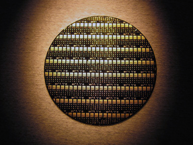
A wafer of GaN-on-Diamond RF devices.

Photo is courtesy of Akash Systems.

The GaN-on-Diamond technology will be integrated into a Ka-band (17.2 to 20.2 GHz) 3U radio transmitter and launched in a 12U CubeSat allowing for new levels of data transmission for customers to increase capacity and reduce end-user costs.

The company’s satellite launch will demonstrate the transmitter’s capability to handle more than five gigabits per second (5Gbps+) downlink speeds from a 10 Watt 3U radio transmitter. Tentatively slated for early 2020, the launch will validate the data rates, reliability and space-qualification readiness of the GaN-on-Diamond transmitter technology.

The new technology enables a smaller, lighter and higher performing satellite that will pave the way to lower launch costs, reduced cost-per-bit, more launch cycles, and increased communications access around the earth.

The company’s satellite launch will demonstrate the transmitter’s capability to handle more than five gigabits per second (5Gbps+) downlink speeds from a 10-Watt 3U radio transmitter. Tentatively slated for early 2020, the launch will validate the data rates, reliability and space-qualification readiness of the GaN-on-Diamond transmitter technology. The new technology enables a smaller, lighter and higher performing satellite that will pave the way to lower launch costs, reduced cost-per-bit, more launch cycles, and increased communications access around the Earth.

Akash will continue to focus on scaling up and qualifying its GaN-on-Diamond Power Amplifier product line, offering customers products with higher frequencies that will be announced in the months ahead.

Executive Comments

Co-founder, CEO and GaN-on-Diamond Inventor Felix Ejeckam said that taking the lead in the satellite communications industry, this demo will showcase the use of the company’s proprietary GaN-on-Diamond Radio Frequency (RF) amplifier technology. Beyond the capability to handle the increasing demands of today’s extreme data throughput, the firm is confident future adoption of the system will drive down end-user costs to levels never before seen.

Jeanette Quinlan, Director of Space Systems, Akash Systems, added that anyone buying the company’s solid-state power amplifiers (SSPAs) to transmit data to or from space will be interested in the space worthiness and reliability of the firm’s SSPA products. This launch helps Akash Systems capture that worthiness and reliability data for them.

The Satellite Applications Catapult Partners with Infostellar to Provide Improved Ground Station Access

The Satellite Applications Catapult and Infostellar have signed a memorandum of understanding (MoU) to provide UK businesses with enhanced access to the Satellite Applications Catapult’s ground station in Goonhilly, Cornwall.

The Catapult’s ground station is the primary ground location for its In Orbit Demonstration (IOD) program, a unique service that supports UK business to achieve the launch of satellite data services. By integrating this ground station with Infostellar’s StellarStation service, organizations will be able to remotely access the Goonhilly station for uplink and downlink. The Catapult will also be able to share unused capacity with the StellarStation network to give greater access to their Goonhilly facility for UK companies.

As a result of this collaboration, Infostellar plans to open a UK office at the Satellite Applications Catapult’s Harwell base in 2019. The UK office will focus on business development and regulatory affairs for Infostellar’s international expansion plans in Europe.

With this agreement, the Satellite Applications Catapult continues to support innovative solutions for the small satellite community, as well as continuing to foster strong links between space companies in the UK and Japan.

Executive Comment

Stuart Martin, CEO of the Satellite Applications Catapult said that the Satellite Applications Catapult is thrilled to sign this new agreement with Infostellar. This will enhance the company’s offering for large and small UK companies and make the Goonhilly ground station more available to participants in the firm’s In-Orbit Demonstration program and the wider space community. This is also another excellent example of how the strength of the space sector in the UK continues to generate great interest from innovative international companies.

The On Orbit Hawkeye360 Pathfinder Smallsats Activated Successfully by Space Flight Laboratory

Space Flight Laboratory (SFL) announced the in-service activation success of the company’s three, formation-flying smallsats that were built by SFL under a contract to Deep Space Industries (now integrated into Bradford Space) for HawkEye 360 Inc.

The smallsats were launched last year into LEO on December 3, 2018, from Vandenberg Air Force Base, California.

The HawkEye 360 Pathfinder smallsats will detect and geolocate radio frequency (RF) signals from VHF radios, maritime radar systems, automatic identification system (AIS) beacons, VSAT terminals and emergency beacons. HawkEye 360 will apply advanced RF analytics to this data to help customers assess suspicious vessel activity, survey communication frequency interference, and search for people in distress.

SFL was selected for the mission by Deep Space Industries, the HawkEye 360 Pathfinder prime contractor, due to the importance of formation flying by multiple satellites for successful RF signal geolocation and analysis. SFL first demonstrated on orbit formation control with smaller satellites in the 2014 with the Canadian CanX-4/CanX-5 mission.

SFL built the three Pathfinder satellites using its space-tested 15 kg. NEMO smallsat bus and incorporated several technologies that make on orbit formation flying possible. Most prominent of these is the high-performance attitude control system developed by SFL to keep smallsats stable in orbit. Included in the formation flying system are a GPS receiver and a high efficiency Comet-1 propulsion unit developed by Deep Space Industries.

Precise formation flying is critical to the HawkEye 360 RF system because the relative positions of each satellite in the constellation must be known to accurately geolocate the transmission sources of the radio frequency signals. For the triangulation to be calculated correctly, each satellite must be located with sufficient precision in space and also be relative to one another.

Executive Comments

John Serafini, the CEO of HawkEye 360, said this is the first time a commercial company has used formation-flying satellites for RF detection.

SFL Director Dr. Robert E. Zee added that the company has developed compact, low-cost formation flying technology that no other small satellite developer can credibly offer. By leveraging SFL’s highly successful formation flying technology demonstrated on orbit, along with DSI’s pioneering innovations and next-generation propulsion systems, the mission will deliver unparalleled performance in smaller, affordable satellites

Chris DeMay, the HawkEye 360 CTO and Founder, noted that the core of the firm’s business is RF analytics, which is dependent upon high-quality, geolocated RF data.